You are here: Home > Network List > XG92 - Rocky Mountain Front Stations List
> Station LED Leadville, CO > Earthquake Result Viewer
LED Leadville, CO - Earthquake Result Viewer
| Earthquake location: |
Near East Coast Of Kamchatka |
| Earthquake latitude/longitude: |
51.2/157.7 |
| Earthquake time(UTC): |
1992/07/13 (195) 15:34:05 GMT |
| Earthquake Depth: |
53 km |
| Earthquake Magnitude: |
5.7 MB |
| Earthquake Catalog/Contributor: |
WHDF/NEIC |
|
| Network: |
XG Rocky Mountain Front |
| Station: |
LED Leadville, CO |
| Lat/Lon: |
39.15 N/106.35 W |
| Elevation: |
2879 m |
|
| Distance: |
64.1 deg |
| Az: |
59.309 deg |
| Baz: |
315.858 deg |
| Ray Param: |
0.05905108 |
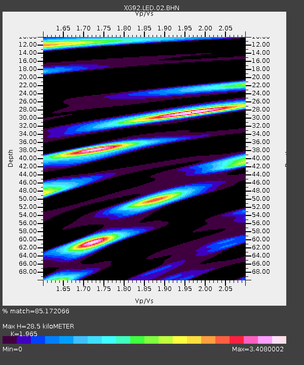
| Estimated Moho Depth: |
28.5 km |
| Estimated Crust Vp/Vs: |
1.97 |
| Assumed Crust Vp: |
6.306 km/s |
| Estimated Crust Vs: |
3.209 km/s |
| Estimated Crust Poisson's Ratio: |
0.33 |
|
| Radial Match: |
85.172066 % |
| Radial Bump: |
400 |
| Transverse Match: |
87.08973 % |
| Transverse Bump: |
400 |
| SOD ConfigId: |
3286 |
| Insert Time: |
2010-02-25 20:09:44.784 +0000 |
| GWidth: |
2.5 |
| Max Bumps: |
400 |
| Tol: |
0.001 |
|
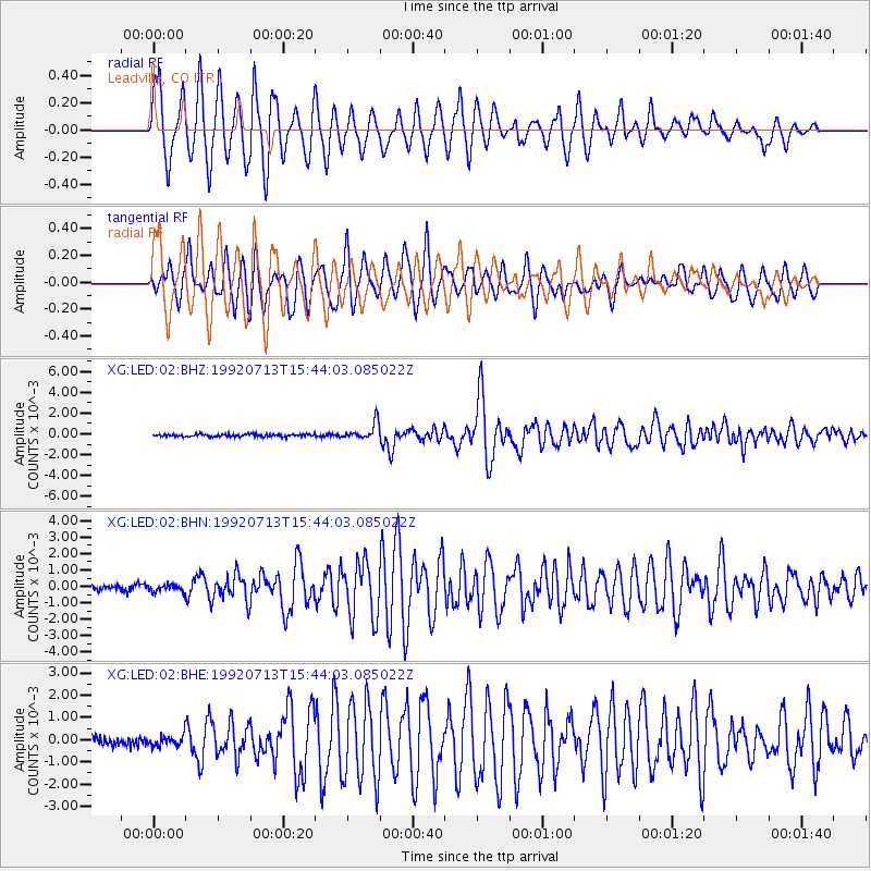
Signal To Noise
| Channel | StoN | STA | LTA |
| XG:LED:02:BHN:19920713T15:44:03.085022Z | 1.0577517 | 2.1169409E-4 | 2.0013592E-4 |
| XG:LED:02:BHE:19920713T15:44:03.085022Z | 1.0240958 | 2.2796365E-4 | 2.2259993E-4 |
| XG:LED:02:BHZ:19920713T15:44:03.085022Z | 6.919945 | 8.1430946E-4 | 1.17675714E-4 |
| Arrivals |
| Ps | 4.5 SECOND |
| PpPs | 13 SECOND |
| PsPs/PpSs | 17 SECOND |


