You are here: Home > Network List > AZ - ANZA Regional Network Stations List
> Station GLA AZ.GLA > Earthquake Result Viewer
GLA AZ.GLA - Earthquake Result Viewer
| Earthquake location: |
Western Honshu, Japan |
| Earthquake latitude/longitude: |
34.1/132.5 |
| Earthquake time(UTC): |
2001/03/24 (083) 06:27:53 GMT |
| Earthquake Depth: |
50 km |
| Earthquake Magnitude: |
6.4 MB, 6.5 MS, 6.8 MW, 6.4 ME |
| Earthquake Catalog/Contributor: |
WHDF/NEIC |
|
| Network: |
AZ ANZA Regional Network |
| Station: |
GLA AZ.GLA |
| Lat/Lon: |
33.05 N/114.83 W |
| Elevation: |
579 m |
|
| Distance: |
88.0 deg |
| Az: |
50.855 deg |
| Baz: |
309.966 deg |
| Ray Param: |
0.042806584 |
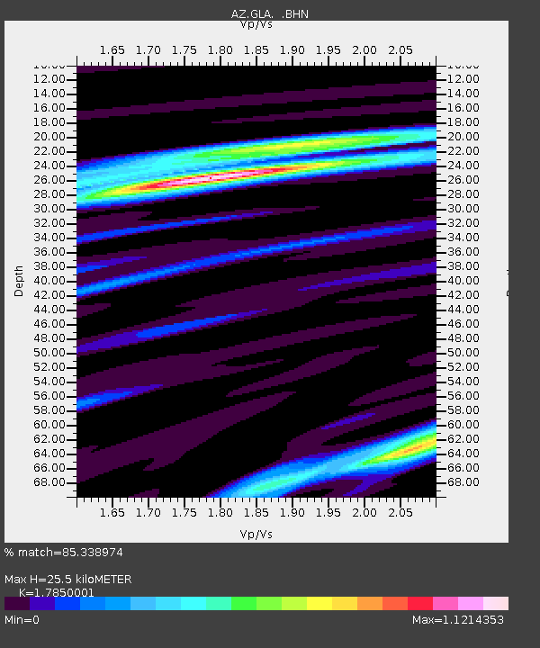
| Estimated Moho Depth: |
25.5 km |
| Estimated Crust Vp/Vs: |
1.79 |
| Assumed Crust Vp: |
6.155 km/s |
| Estimated Crust Vs: |
3.448 km/s |
| Estimated Crust Poisson's Ratio: |
0.27 |
|
| Radial Match: |
85.338974 % |
| Radial Bump: |
400 |
| Transverse Match: |
71.94989 % |
| Transverse Bump: |
400 |
| SOD ConfigId: |
4714 |
| Insert Time: |
2010-02-26 19:23:58.232 +0000 |
| GWidth: |
2.5 |
| Max Bumps: |
400 |
| Tol: |
0.001 |
|
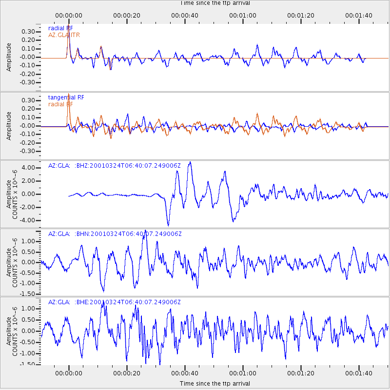
Signal To Noise
| Channel | StoN | STA | LTA |
| AZ:GLA: :BHN:20010324T06:40:07.249006Z | 2.3703098 | 3.9198224E-7 | 1.6537173E-7 |
| AZ:GLA: :BHE:20010324T06:40:07.249006Z | 1.6657035 | 5.653793E-7 | 3.394237E-7 |
| AZ:GLA: :BHZ:20010324T06:40:07.249006Z | 13.205298 | 1.8565185E-6 | 1.4058891E-7 |
| Arrivals |
| Ps | 3.3 SECOND |
| PpPs | 11 SECOND |
| PsPs/PpSs | 15 SECOND |


