
Station AZ GLA - AZ.GLA
Network: AZ - ANZA Regional Network
Nearby stations (2 deg radius)
| Station | Name | (Lat, Lon) | Start / End | Elevation |
| GLA | AZ.GLA | (33.05, -114.83) | 2000-11-06 / 2001-06-01 | 579 m |
| Crust2 Type: | ME,very thin extended crust, 1.5 km seds. |
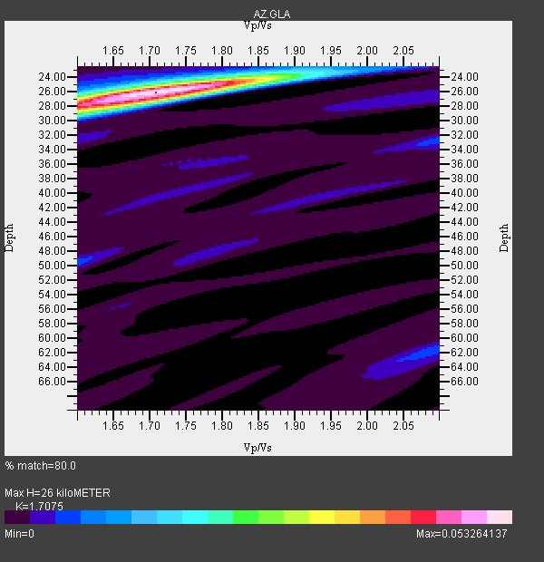
| Thickness Estimate: | 26 km |
| Thickness StdDev: | 0.5 km |
| Vp/Vs Estimate: | 1.71 |
| Vp/Vs StdDev: | 0.03 |
| Vs Estimate: | 3.604 km/s |
| Poisson's Ratio: | 0.24 |
| Peak Value: | 0.05 |
| Assumed Vp: | 6.155 km/s |
| Ps Weight: | 0.33333334 |
| PpPs Weight: | 0.33333334 |
| PsPs Weight: | 0.33333328 |
| Residual Complexity: | 0.295 |
| Nearby stations H: | 27 km +- 0.6 km |
| (2.0 deg) Vp/Vs: | 1.67 +- 0.03 |
6 with match > 90% ( 42.857143 %) and 14 with match > 80% ( 100.0 %) out of 14.
Download stack as xyz text file.
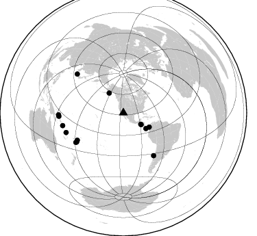
Azimuth Distribution of Events:
Prior Results for this Station
| Study | Thickness | Vp/Vs | Vp | Vs | Poissons Ratio | Extra |
| EARS | 26 km | 1.71 | 6.155 km/s | 3.604 km/s | 0.24 | |
| Crust2.0 | 28 km | 1.78 | 6.155 km/s | 3.46 km/s | 0.27 | ME,very thin extended crust, 1.5 km seds. |
| Zhu S. Cal. | 27 km | 1.72 | 6.3 km/s | 3.663 km/s | 0.24 | |
| Global Maxima | 26 km | 1.71 | 6.155 km/s | 3.604 km/s | 0.24 | amp=0.053264137 |
| Local Maxima 1 | 28 km | 1.60 | 6.155 km/s | 3.841 km/s | 0.18 | amp=0.01984763 |
| Local Maxima 2 | 24 km | 1.84 | 6.155 km/s | 3.354 km/s | 0.29 | amp=0.013466592 |
| Local Maxima 3 | 33 km | 2.10 | 6.155 km/s | 2.934 km/s | 0.35 | amp=0.00734022 |
| Local Maxima 4 | 50 km | 1.60 | 6.155 km/s | 3.847 km/s | 0.18 | amp=0.006481843 |
| Predicted Arrivals for vertical incidence (zero ray parameter) | |
| Ps | 2.99 SECOND |
| PpPs | 11.44 SECOND |
| PsPs/PpSs | 14.43 SECOND |
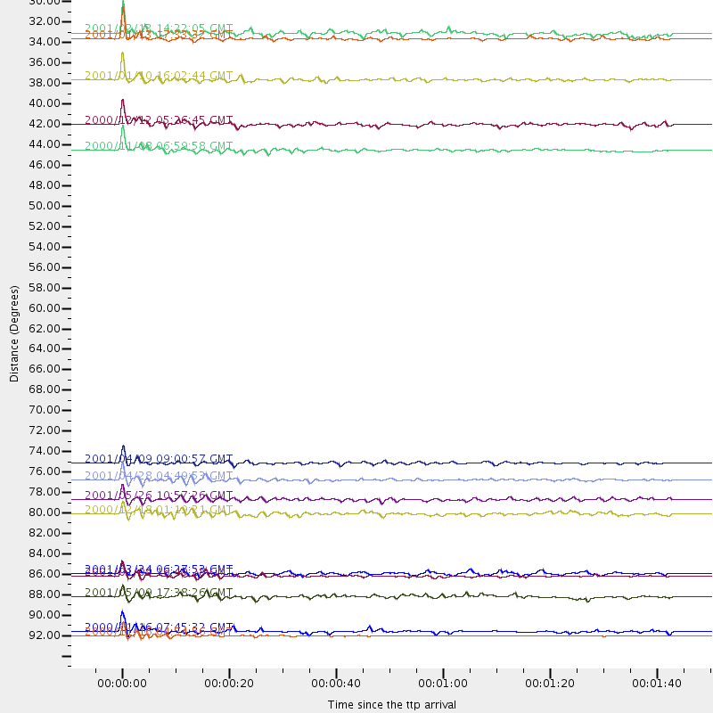
Events Processed for this Station
Download zip of receiver functions as SAC
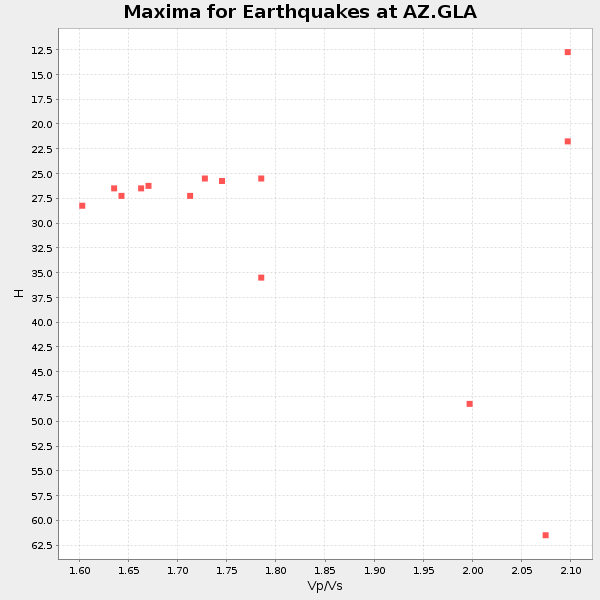
Plot maxima for each earthquake.
Events Used in the Stack
(14 events)| Radial Match | Distance | Baz | FERegion | Time | Lat/Lon | Depth | Magnitude |
| 98.089035 | 31.1 deg | 123.676 deg | El Salvador | 2001/01/13 17:33:32 GMT | (13.0, -88.7) | 60 km | 6.4 MB, 7.8 MS, 7.7 MW, 7.5 ME |
| 94.68647 | 76.3 deg | 144.706 deg | Off Coast Of Central Chile | 2001/04/09 09:00:57 GMT | (-32.7, -73.1) | 11 km | 6.1 MB, 6.3 MS, 6.7 MW, 6.3 ME |
| 94.59703 | 94.7 deg | 268.302 deg | New Ireland Region, P.N.G. | 2000/11/16 04:54:56 GMT | (-4.0, 152.2) | 33 km | 6.0 MB, 8.2 MS, 8.0 MW, 8.0 ME |
| 93.07388 | 88.3 deg | 251.082 deg | Vanuatu Islands | 2001/01/09 16:49:28 GMT | (-14.9, 167.2) | 103 km | 6.3 MB, 6.6 MS, 7.6 ME, 7.0 MW |
| 92.25115 | 43.0 deg | 118.773 deg | Panama-Colombia Border Region | 2000/11/08 06:59:58 GMT | (7.0, -77.8) | 17 km | 6.0 MB, 6.4 MS, 6.5 MW, 6.2 ML |
| 91.5395 | 35.5 deg | 324.263 deg | Kodiak Island Region, Alaska | 2001/01/10 16:02:44 GMT | (57.1, -153.2) | 33 km | 6.2 MB, 6.8 MS, 7.1 MW, 6.8 ML |
| 89.35952 | 78.1 deg | 239.242 deg | Fiji Islands Region | 2001/04/28 04:49:53 GMT | (-18.1, -176.9) | 352 km | 6.2 MB, 6.8 MW, 6.8 MW |
| 87.54898 | 90.5 deg | 258.121 deg | Solomon Islands | 2001/05/09 17:38:26 GMT | (-10.3, 161.2) | 68 km | 6.0 MB, 5.9 MS, 6.3 MW, 6.2 MW |
| 87.12902 | 40.2 deg | 124.935 deg | South Of Panama | 2000/12/12 05:26:45 GMT | (6.0, -82.7) | 10 km | 5.8 MB, 5.7 MS, 6.3 ME, 6.1 MW |
| 85.338974 | 88.0 deg | 309.966 deg | Western Honshu, Japan | 2001/03/24 06:27:53 GMT | (34.1, 132.5) | 50 km | 6.4 MB, 6.5 MS, 6.8 MW, 6.4 ME |
| 82.79972 | 81.7 deg | 238.202 deg | Fiji Islands Region | 2000/12/18 01:19:21 GMT | (-21.2, -179.1) | 628 km | 6.4 MB, 6.6 MW, 6.5 MW |
| 82.790276 | 94.2 deg | 267.021 deg | New Ireland Region, P.N.G. | 2000/11/16 07:45:32 GMT | (-4.8, 153.2) | 33 km | 6.5 MB, 7.2 MS |
| 81.16861 | 80.2 deg | 238.096 deg | Fiji Islands Region | 2001/05/26 10:57:26 GMT | (-20.3, -177.8) | 406 km | 5.3 MB, 6.4 MW, 6.4 MW |
| 81.10248 | 30.5 deg | 123.173 deg | El Salvador | 2001/02/13 14:22:05 GMT | (13.7, -88.9) | 10 km | 5.5 MB, 6.5 MS, 6.6 MW, 6.1 MD |
Losers
(0 events)| Radial Match | Distance | Baz | FERegion | Time | Lat/Lon | Depth | Magnitude | Reason |
