You are here: Home > Network List > AZ - ANZA Regional Network Stations List
> Station GLA AZ.GLA > Earthquake Result Viewer
GLA AZ.GLA - Earthquake Result Viewer
| Earthquake location: |
El Salvador |
| Earthquake latitude/longitude: |
13.0/-88.7 |
| Earthquake time(UTC): |
2001/01/13 (013) 17:33:32 GMT |
| Earthquake Depth: |
60 km |
| Earthquake Magnitude: |
6.4 MB, 7.8 MS, 7.7 MW, 7.5 ME |
| Earthquake Catalog/Contributor: |
WHDF/NEIC |
|
| Network: |
AZ ANZA Regional Network |
| Station: |
GLA AZ.GLA |
| Lat/Lon: |
33.05 N/114.83 W |
| Elevation: |
579 m |
|
| Distance: |
31.1 deg |
| Az: |
314.177 deg |
| Baz: |
123.676 deg |
| Ray Param: |
0.079077 |
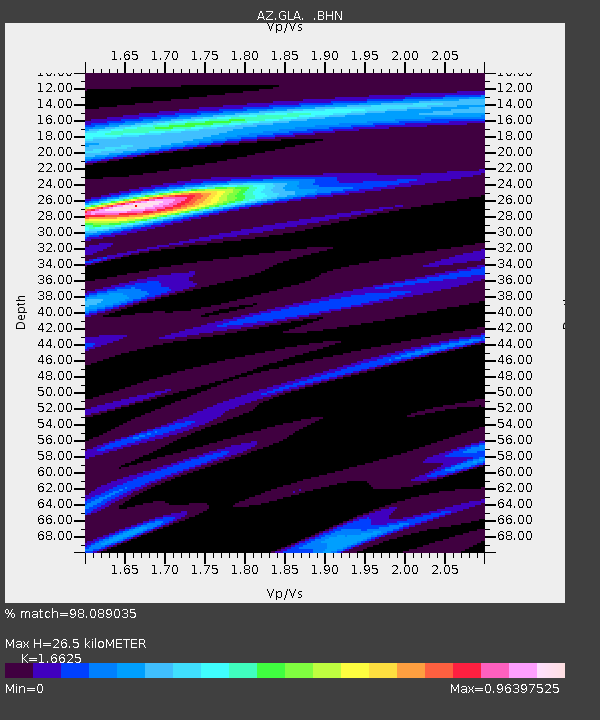
| Estimated Moho Depth: |
26.5 km |
| Estimated Crust Vp/Vs: |
1.66 |
| Assumed Crust Vp: |
6.155 km/s |
| Estimated Crust Vs: |
3.702 km/s |
| Estimated Crust Poisson's Ratio: |
0.22 |
|
| Radial Match: |
98.089035 % |
| Radial Bump: |
230 |
| Transverse Match: |
83.15232 % |
| Transverse Bump: |
400 |
| SOD ConfigId: |
3744 |
| Insert Time: |
2010-02-26 19:24:00.214 +0000 |
| GWidth: |
2.5 |
| Max Bumps: |
400 |
| Tol: |
0.001 |
|

Signal To Noise
| Channel | StoN | STA | LTA |
| AZ:GLA: :BHN:20010113T17:39:14.748988Z | 1.8669835 | 6.790304E-7 | 3.6370454E-7 |
| AZ:GLA: :BHE:20010113T17:39:14.748988Z | 4.7531796 | 1.7512139E-6 | 3.6843E-7 |
| AZ:GLA: :BHZ:20010113T17:39:14.748988Z | 7.446745 | 3.2179792E-6 | 4.3213234E-7 |
| Arrivals |
| Ps | 3.1 SECOND |
| PpPs | 11 SECOND |
| PsPs/PpSs | 14 SECOND |


