You are here: Home > Network List > AZ - ANZA Regional Network Stations List
> Station GLA AZ.GLA > Earthquake Result Viewer
GLA AZ.GLA - Earthquake Result Viewer
| Earthquake location: |
El Salvador |
| Earthquake latitude/longitude: |
13.7/-88.9 |
| Earthquake time(UTC): |
2001/02/13 (044) 14:22:05 GMT |
| Earthquake Depth: |
10 km |
| Earthquake Magnitude: |
5.5 MB, 6.5 MS, 6.6 MW, 6.1 MD |
| Earthquake Catalog/Contributor: |
WHDF/NEIC |
|
| Network: |
AZ ANZA Regional Network |
| Station: |
GLA AZ.GLA |
| Lat/Lon: |
33.05 N/114.83 W |
| Elevation: |
579 m |
|
| Distance: |
30.5 deg |
| Az: |
313.68 deg |
| Baz: |
123.173 deg |
| Ray Param: |
0.07932425 |
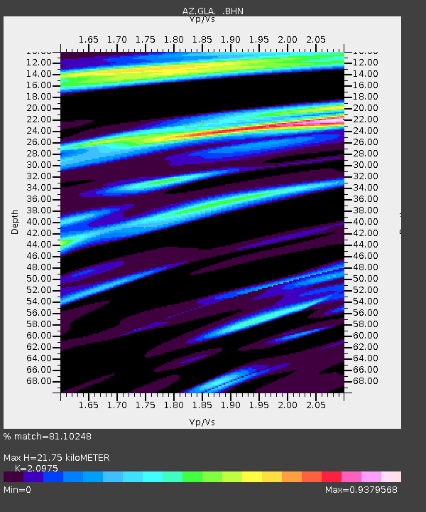
| Estimated Moho Depth: |
21.75 km |
| Estimated Crust Vp/Vs: |
2.10 |
| Assumed Crust Vp: |
6.155 km/s |
| Estimated Crust Vs: |
2.934 km/s |
| Estimated Crust Poisson's Ratio: |
0.35 |
|
| Radial Match: |
81.10248 % |
| Radial Bump: |
321 |
| Transverse Match: |
52.147972 % |
| Transverse Bump: |
353 |
| SOD ConfigId: |
3744 |
| Insert Time: |
2010-02-26 19:24:03.734 +0000 |
| GWidth: |
2.5 |
| Max Bumps: |
400 |
| Tol: |
0.001 |
|

Signal To Noise
| Channel | StoN | STA | LTA |
| AZ:GLA: :BHN:20010213T14:27:47.998986Z | 1.7862113 | 5.138374E-7 | 2.8766888E-7 |
| AZ:GLA: :BHE:20010213T14:27:47.998986Z | 1.4436635 | 4.0341E-7 | 2.7943491E-7 |
| AZ:GLA: :BHZ:20010213T14:27:47.998986Z | 1.277765 | 3.0280034E-7 | 2.3697655E-7 |
| Arrivals |
| Ps | 4.1 SECOND |
| PpPs | 10 SECOND |
| PsPs/PpSs | 14 SECOND |


