You are here: Home > Network List > AZ - ANZA Regional Network Stations List
> Station GLA AZ.GLA > Earthquake Result Viewer
GLA AZ.GLA - Earthquake Result Viewer
| Earthquake location: |
Fiji Islands Region |
| Earthquake latitude/longitude: |
-20.3/-177.8 |
| Earthquake time(UTC): |
2001/05/26 (146) 10:57:26 GMT |
| Earthquake Depth: |
406 km |
| Earthquake Magnitude: |
5.3 MB, 6.4 MW, 6.4 MW |
| Earthquake Catalog/Contributor: |
WHDF/NEIC |
|
| Network: |
AZ ANZA Regional Network |
| Station: |
GLA AZ.GLA |
| Lat/Lon: |
33.05 N/114.83 W |
| Elevation: |
579 m |
|
| Distance: |
80.2 deg |
| Az: |
49.424 deg |
| Baz: |
238.096 deg |
| Ray Param: |
0.04731965 |
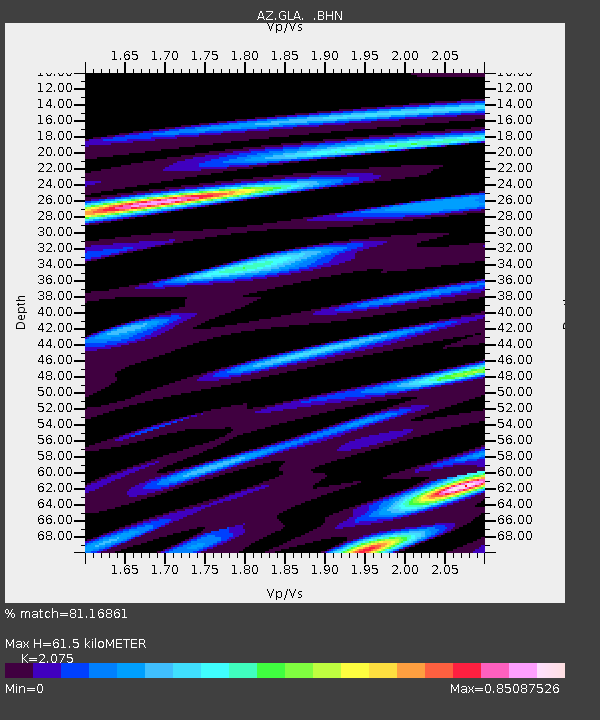
| Estimated Moho Depth: |
61.5 km |
| Estimated Crust Vp/Vs: |
2.08 |
| Assumed Crust Vp: |
6.155 km/s |
| Estimated Crust Vs: |
2.966 km/s |
| Estimated Crust Poisson's Ratio: |
0.35 |
|
| Radial Match: |
81.16861 % |
| Radial Bump: |
354 |
| Transverse Match: |
60.44719 % |
| Transverse Bump: |
400 |
| SOD ConfigId: |
4714 |
| Insert Time: |
2010-02-26 19:24:09.260 +0000 |
| GWidth: |
2.5 |
| Max Bumps: |
400 |
| Tol: |
0.001 |
|

Signal To Noise
| Channel | StoN | STA | LTA |
| AZ:GLA: :BHN:20010526T11:08:21.475012Z | 4.212745 | 1.3878218E-7 | 3.2943408E-8 |
| AZ:GLA: :BHE:20010526T11:08:21.475012Z | 1.8451431 | 9.4953116E-8 | 5.146111E-8 |
| AZ:GLA: :BHZ:20010526T11:08:21.475012Z | 6.269749 | 5.021473E-7 | 8.00905E-8 |
| Arrivals |
| Ps | 11 SECOND |
| PpPs | 30 SECOND |
| PsPs/PpSs | 41 SECOND |


