You are here: Home > Network List > AZ - ANZA Regional Network Stations List
> Station GLA AZ.GLA > Earthquake Result Viewer
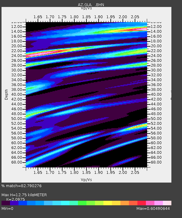
GLA AZ.GLA - Earthquake Result Viewer
| Earthquake location: |
New Ireland Region, P.N.G. |
| Earthquake latitude/longitude: |
-4.8/153.2 |
| Earthquake time(UTC): |
2000/11/16 (321) 07:45:32 GMT |
| Earthquake Depth: |
33 km |
| Earthquake Magnitude: |
6.5 MB, 7.2 MS |
| Earthquake Catalog/Contributor: |
WHDF/NEIC |
|
| Network: |
AZ ANZA Regional Network |
| Station: |
GLA AZ.GLA |
| Lat/Lon: |
33.05 N/114.83 W |
| Elevation: |
579 m |
|
| Distance: |
94.2 deg |
| Az: |
57.316 deg |
| Baz: |
267.021 deg |
| Ray Param: |
0.041078728 |
| Estimated Moho Depth: |
12.75 km |
| Estimated Crust Vp/Vs: |
2.10 |
| Assumed Crust Vp: |
6.155 km/s |
| Estimated Crust Vs: |
2.934 km/s |
| Estimated Crust Poisson's Ratio: |
0.35 |
|
| Radial Match: |
82.790276 % |
| Radial Bump: |
348 |
| Transverse Match: |
45.264103 % |
| Transverse Bump: |
397 |
| SOD ConfigId: |
3744 |
| Insert Time: |
2010-02-26 19:24:11.132 +0000 |
| GWidth: |
2.5 |
| Max Bumps: |
400 |
| Tol: |
0.001 |
|

Signal To Noise
| Channel | StoN | STA | LTA |
| AZ:GLA: :BHN:20001116T07:58:17.275022Z | 1.0955318 | 2.061528E-6 | 1.8817601E-6 |
| AZ:GLA: :BHE:20001116T07:58:17.275022Z | 1.7015129 | 3.3141873E-6 | 1.9477886E-6 |
| AZ:GLA: :BHZ:20001116T07:58:17.275022Z | 1.2749146 | 3.1216568E-6 | 2.4485223E-6 |
| Arrivals |
| Ps | 2.3 SECOND |
| PpPs | 6.3 SECOND |
| PsPs/PpSs | 8.6 SECOND |


