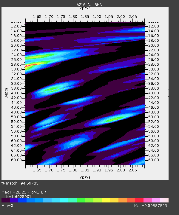
GLA AZ.GLA - Earthquake Result Viewer
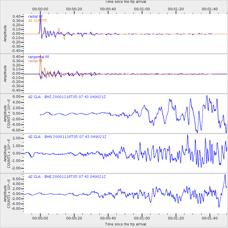
Earthquake location: New Ireland Region, P.N.G.
Earthquake latitude/longitude: -4.0/152.2
Earthquake time(UTC): 2000/11/16 (321) 04:54:56 GMT
Earthquake Depth: 33 km
Earthquake Magnitude: 6.0 MB, 8.2 MS, 8.0 MW, 8.0 ME
Earthquake Catalog/Contributor: WHDF/NEIC
Network: AZ ANZA Regional Network
Station: GLA AZ.GLA
Lat/Lon: 33.05 N/114.83 W
Elevation: 579 m
Distance: 94.7 deg
Az: 57.297 deg
Baz: 268.302 deg
Ray Param: 0.04097305
Estimated Moho Depth: 28.25 km
Estimated Crust Vp/Vs: 1.60
Assumed Crust Vp: 6.155 km/s
Estimated Crust Vs: 3.841 km/s
Estimated Crust Poisson's Ratio: 0.18
Radial Match: 94.59703 %
Radial Bump: 390
Transverse Match: 75.3486 %
Transverse Bump: 400
SOD ConfigId: 3744
Insert Time: 2010-02-26 19:24:12.438 +0000
GWidth: 2.5
Max Bumps: 400
Tol: 0.001

Signal To Noise

ChannelStoNSTALTA
AZ:GLA: :BHN:20001116T05:07:43.049021Z0.348940227.2383074E-82.074369E-7
AZ:GLA: :BHE:20001116T05:07:43.049021Z1.28210472.764461E-72.1561895E-7
AZ:GLA: :BHZ:20001116T05:07:43.049021Z0.79114712.2223506E-72.8090233E-7
Arrivals
Ps2.8 SECOND
PpPs12 SECOND
PsPs/PpSs15 SECOND