You are here: Home > Network List > AZ - ANZA Regional Network Stations List
> Station GLA AZ.GLA > Earthquake Result Viewer
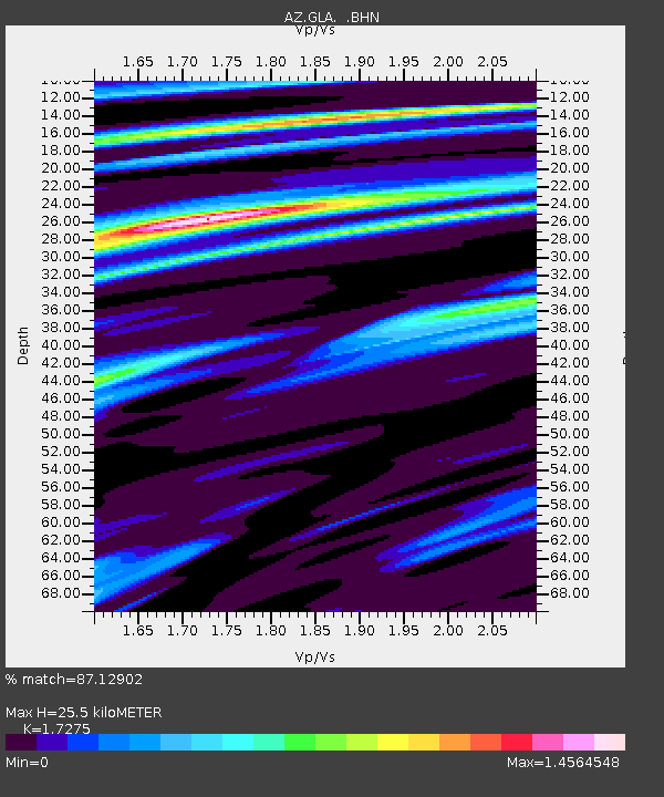
GLA AZ.GLA - Earthquake Result Viewer
| Earthquake location: |
South Of Panama |
| Earthquake latitude/longitude: |
6.0/-82.7 |
| Earthquake time(UTC): |
2000/12/12 (347) 05:26:45 GMT |
| Earthquake Depth: |
10 km |
| Earthquake Magnitude: |
5.8 MB, 5.7 MS, 6.3 ME, 6.1 MW |
| Earthquake Catalog/Contributor: |
WHDF/NEIC |
|
| Network: |
AZ ANZA Regional Network |
| Station: |
GLA AZ.GLA |
| Lat/Lon: |
33.05 N/114.83 W |
| Elevation: |
579 m |
|
| Distance: |
40.2 deg |
| Az: |
316.19 deg |
| Baz: |
124.935 deg |
| Ray Param: |
0.0745267 |
| Estimated Moho Depth: |
25.5 km |
| Estimated Crust Vp/Vs: |
1.73 |
| Assumed Crust Vp: |
6.155 km/s |
| Estimated Crust Vs: |
3.563 km/s |
| Estimated Crust Poisson's Ratio: |
0.25 |
|
| Radial Match: |
87.12902 % |
| Radial Bump: |
396 |
| Transverse Match: |
59.66661 % |
| Transverse Bump: |
400 |
| SOD ConfigId: |
3744 |
| Insert Time: |
2010-02-26 19:24:14.204 +0000 |
| GWidth: |
2.5 |
| Max Bumps: |
400 |
| Tol: |
0.001 |
|

Signal To Noise
| Channel | StoN | STA | LTA |
| AZ:GLA: :BHN:20001212T05:33:51.62399Z | 0.68239164 | 1.0246845E-7 | 1.5016076E-7 |
| AZ:GLA: :BHE:20001212T05:33:51.62399Z | 0.58480483 | 1.3715241E-7 | 2.3452681E-7 |
| AZ:GLA: :BHZ:20001212T05:33:51.62399Z | 0.75096613 | 1.7611535E-7 | 2.3451835E-7 |
| Arrivals |
| Ps | 3.2 SECOND |
| PpPs | 11 SECOND |
| PsPs/PpSs | 14 SECOND |


