You are here: Home > Network List > TA - USArray Transportable Network (new EarthScope stations) Stations List
> Station 034A Hebronville, TX, USA > Earthquake Result Viewer
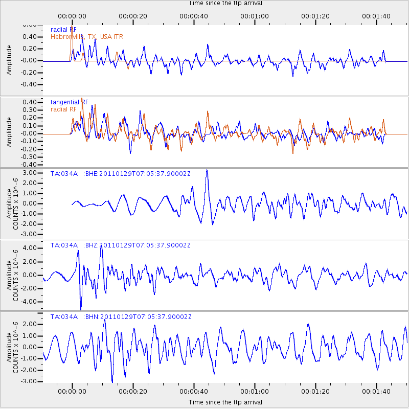
034A Hebronville, TX, USA - Earthquake Result Viewer
*The percent match for this event was below the threshold and hence no stack was calculated.
| Earthquake location: |
Jan Mayen Island Region |
| Earthquake latitude/longitude: |
70.9/-6.7 |
| Earthquake time(UTC): |
2011/01/29 (029) 06:55:26 GMT |
| Earthquake Depth: |
6.0 km |
| Earthquake Magnitude: |
6.1 MB, 6.1 MS, 6.2 MW, 6.2 MW |
| Earthquake Catalog/Contributor: |
WHDF/NEIC |
|
| Network: |
TA USArray Transportable Network (new EarthScope stations) |
| Station: |
034A Hebronville, TX, USA |
| Lat/Lon: |
27.06 N/98.68 W |
| Elevation: |
155 m |
|
| Distance: |
65.3 deg |
| Az: |
281.306 deg |
| Baz: |
21.182 deg |
| Ray Param: |
$rayparam |
*The percent match for this event was below the threshold and hence was not used in the summary stack. |
|
| Radial Match: |
64.81129 % |
| Radial Bump: |
396 |
| Transverse Match: |
72.3498 % |
| Transverse Bump: |
371 |
| SOD ConfigId: |
350818 |
| Insert Time: |
2011-07-20 08:53:22.540 +0000 |
| GWidth: |
2.5 |
| Max Bumps: |
400 |
| Tol: |
0.001 |
|
Signal To Noise
| Channel | StoN | STA | LTA |
| TA:034A: :BHZ:20110129T07:05:37.90002Z | 5.9935846 | 1.9963013E-6 | 3.3307302E-7 |
| TA:034A: :BHN:20110129T07:05:37.90002Z | 1.033777 | 8.2232384E-7 | 7.954557E-7 |
| TA:034A: :BHE:20110129T07:05:37.90002Z | 1.297011 | 5.735688E-7 | 4.4222352E-7 |
| Arrivals |
| Ps | |
| PpPs | |
| PsPs/PpSs | |


