You are here: Home > Network List > TA - USArray Transportable Network (new EarthScope stations) Stations List
> Station 034A Hebronville, TX, USA > Earthquake Result Viewer
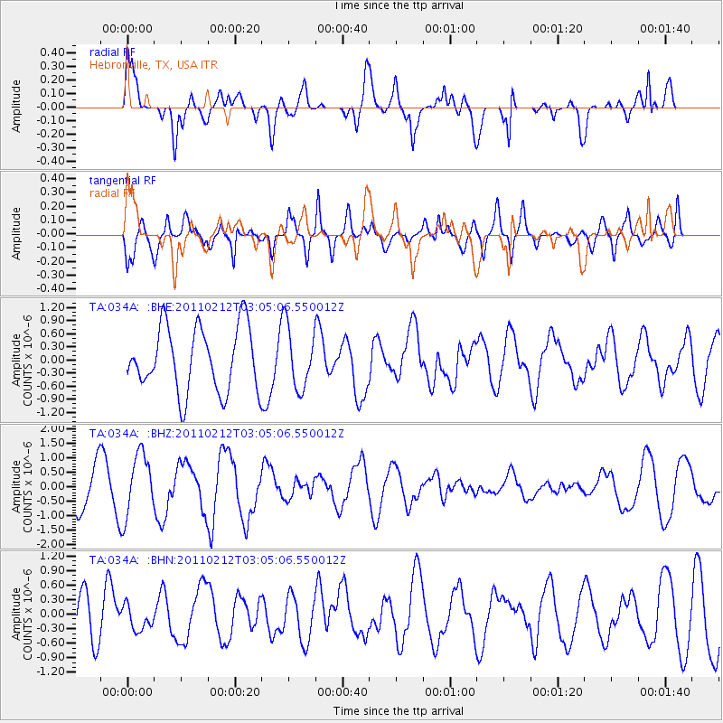
034A Hebronville, TX, USA - Earthquake Result Viewer
*The percent match for this event was below the threshold and hence no stack was calculated.
| Earthquake location: |
North Of Ascension Island |
| Earthquake latitude/longitude: |
0.1/-17.0 |
| Earthquake time(UTC): |
2011/02/12 (043) 02:53:15 GMT |
| Earthquake Depth: |
10 km |
| Earthquake Magnitude: |
5.5 MB, 5.6 MW |
| Earthquake Catalog/Contributor: |
WHDF/NEIC |
|
| Network: |
TA USArray Transportable Network (new EarthScope stations) |
| Station: |
034A Hebronville, TX, USA |
| Lat/Lon: |
27.06 N/98.68 W |
| Elevation: |
155 m |
|
| Distance: |
82.5 deg |
| Az: |
297.146 deg |
| Baz: |
93.723 deg |
| Ray Param: |
$rayparam |
*The percent match for this event was below the threshold and hence was not used in the summary stack. |
|
| Radial Match: |
63.630043 % |
| Radial Bump: |
400 |
| Transverse Match: |
62.6476 % |
| Transverse Bump: |
400 |
| SOD ConfigId: |
350818 |
| Insert Time: |
2011-07-26 07:07:28.444 +0000 |
| GWidth: |
2.5 |
| Max Bumps: |
400 |
| Tol: |
0.001 |
|
Signal To Noise
| Channel | StoN | STA | LTA |
| TA:034A: :BHZ:20110212T03:05:06.550012Z | 1.8680946 | 1.0560545E-6 | 5.6531104E-7 |
| TA:034A: :BHN:20110212T03:05:06.550012Z | 0.6508915 | 2.4470202E-7 | 3.75949E-7 |
| TA:034A: :BHE:20110212T03:05:06.550012Z | 0.9592708 | 7.042282E-7 | 7.341287E-7 |
| Arrivals |
| Ps | |
| PpPs | |
| PsPs/PpSs | |


