You are here: Home > Network List > XG92 - Rocky Mountain Front Stations List
> Station MKR Meeker, CO > Earthquake Result Viewer
MKR Meeker, CO - Earthquake Result Viewer
| Earthquake location: |
Fiji Islands Region |
| Earthquake latitude/longitude: |
-17.7/-178.8 |
| Earthquake time(UTC): |
1992/08/30 (243) 20:09:06 GMT |
| Earthquake Depth: |
573 km |
| Earthquake Magnitude: |
5.8 MB |
| Earthquake Catalog/Contributor: |
WHDF/NEIC |
|
| Network: |
XG Rocky Mountain Front |
| Station: |
MKR Meeker, CO |
| Lat/Lon: |
40.03 N/107.74 W |
| Elevation: |
2045 m |
|
| Distance: |
87.5 deg |
| Az: |
46.619 deg |
| Baz: |
244.444 deg |
| Ray Param: |
0.041727073 |
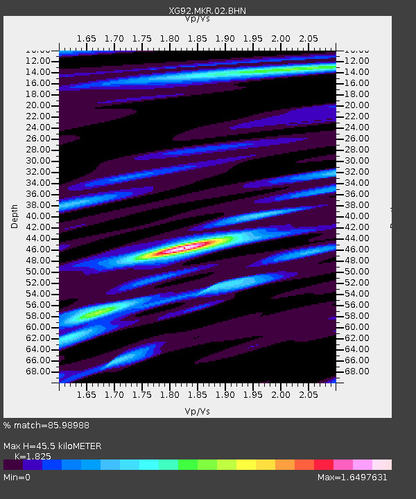
| Estimated Moho Depth: |
45.5 km |
| Estimated Crust Vp/Vs: |
1.83 |
| Assumed Crust Vp: |
6.159 km/s |
| Estimated Crust Vs: |
3.375 km/s |
| Estimated Crust Poisson's Ratio: |
0.29 |
|
| Radial Match: |
85.98988 % |
| Radial Bump: |
400 |
| Transverse Match: |
77.0493 % |
| Transverse Bump: |
400 |
| SOD ConfigId: |
3286 |
| Insert Time: |
2010-02-25 20:10:23.355 +0000 |
| GWidth: |
2.5 |
| Max Bumps: |
400 |
| Tol: |
0.001 |
|

Signal To Noise
| Channel | StoN | STA | LTA |
| XG:MKR:02:BHN:19920830T20:20:22.967017Z | 1.6032685 | 7.236202E-5 | 4.513406E-5 |
| XG:MKR:02:BHE:19920830T20:20:22.967017Z | 6.894087 | 2.8140328E-4 | 4.0818064E-5 |
| XG:MKR:02:BHZ:19920830T20:20:22.967017Z | 18.762604 | 8.1489247E-4 | 4.3431737E-5 |
| Arrivals |
| Ps | 6.2 SECOND |
| PpPs | 20 SECOND |
| PsPs/PpSs | 27 SECOND |


