You are here: Home > Network List > XG92 - Rocky Mountain Front Stations List
> Station MON Montrose, CO > Earthquake Result Viewer
MON Montrose, CO - Earthquake Result Viewer
| Earthquake location: |
Fiji Islands Region |
| Earthquake latitude/longitude: |
-17.7/-178.8 |
| Earthquake time(UTC): |
1992/08/30 (243) 20:09:06 GMT |
| Earthquake Depth: |
573 km |
| Earthquake Magnitude: |
5.8 MB |
| Earthquake Catalog/Contributor: |
WHDF/NEIC |
|
| Network: |
XG Rocky Mountain Front |
| Station: |
MON Montrose, CO |
| Lat/Lon: |
38.53 N/108.00 W |
| Elevation: |
2097 m |
|
| Distance: |
86.7 deg |
| Az: |
47.888 deg |
| Baz: |
244.349 deg |
| Ray Param: |
0.042248137 |
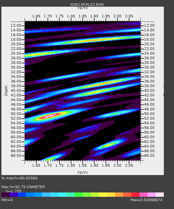
| Estimated Moho Depth: |
50.75 km |
| Estimated Crust Vp/Vs: |
1.71 |
| Assumed Crust Vp: |
6.306 km/s |
| Estimated Crust Vs: |
3.699 km/s |
| Estimated Crust Poisson's Ratio: |
0.24 |
|
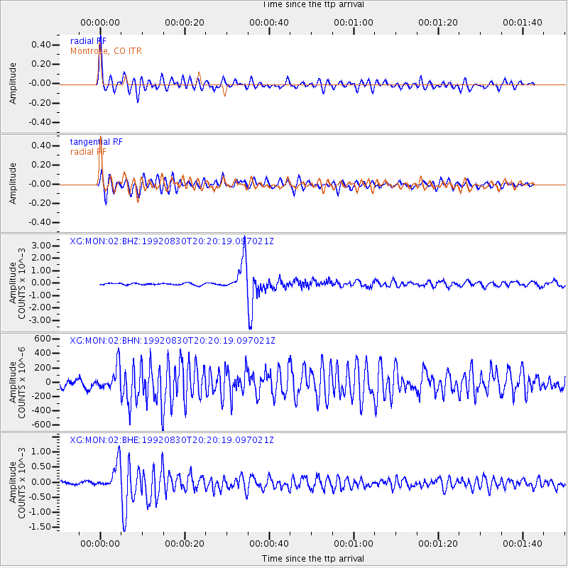
| Radial Match: |
90.80596 % |
| Radial Bump: |
400 |
| Transverse Match: |
86.932724 % |
| Transverse Bump: |
400 |
| SOD ConfigId: |
3286 |
| Insert Time: |
2010-02-25 20:10:26.853 +0000 |
| GWidth: |
2.5 |
| Max Bumps: |
400 |
| Tol: |
0.001 |
|
Signal To Noise
| Channel | StoN | STA | LTA |
| XG:MON:02:BHN:19920830T20:20:19.097021Z | 3.2306285 | 1.6369192E-4 | 5.0668754E-5 |
| XG:MON:02:BHE:19920830T20:20:19.097021Z | 10.983088 | 4.6878605E-4 | 4.268254E-5 |
| XG:MON:02:BHZ:19920830T20:20:19.097021Z | 19.45463 | 0.0013422825 | 6.8995534E-5 |
| Arrivals |
| Ps | 5.8 SECOND |
| PpPs | 21 SECOND |
| PsPs/PpSs | 27 SECOND |


