
Station XG MON - Montrose, CO
Network: XG92 - Rocky Mountain Front
Nearby stations (2 deg radius)
| Station | Name | (Lat, Lon) | Start / End | Elevation |
| MON | Montrose, CO | (38.53, -108.00) | 1992-05-23 / 2499-01-01 | 2.1 km |
| Crust2 Type: | P4,orogen/50km, Urals, Tethian Orogen, Rockies 1 km seds. |
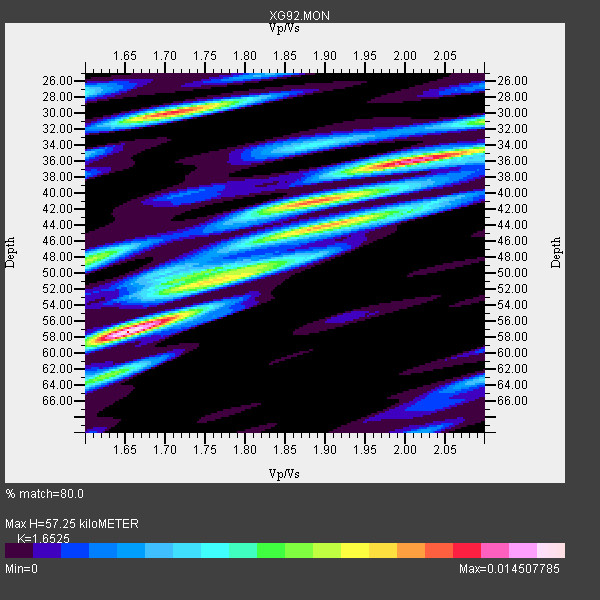
| Thickness Estimate: | 57 km |
| Thickness StdDev: | 11 km |
| Vp/Vs Estimate: | 1.65 |
| Vp/Vs StdDev: | 0.16 |
| Vs Estimate: | 3.816 km/s |
| Poisson's Ratio: | 0.21 |
| Peak Value: | 0.01 |
| Assumed Vp: | 6.306 km/s |
| Ps Weight: | 0.33333334 |
| PpPs Weight: | 0.33333334 |
| PsPs Weight: | 0.33333328 |
| Residual Complexity: | 0.847 |
| Nearby stations H: | +- |
| (2.0 deg) Vp/Vs: | +- |
9 with match > 90% ( 69.23077 %) and 13 with match > 80% ( 100.0 %) out of 13.
Download stack as xyz text file.
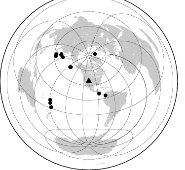
Azimuth Distribution of Events:
Prior Results for this Station
| Study | Thickness | Vp/Vs | Vp | Vs | Poissons Ratio | Extra |
| EARS | 57 km | 1.65 | 6.306 km/s | 3.816 km/s | 0.21 | |
| Crust2.0 | 50 km | 1.76 | 6.306 km/s | 3.584 km/s | 0.26 | P4,orogen/50km, Urals, Tethian Orogen, Rockies 1 km seds. |
| Global Maxima | 57 km | 1.65 | 6.306 km/s | 3.816 km/s | 0.21 | amp=0.014507785 |
| Local Maxima 1 | 36 km | 2.00 | 6.306 km/s | 3.153 km/s | 0.33 | amp=0.011873506 |
| Local Maxima 2 | 30 km | 1.71 | 6.306 km/s | 3.682 km/s | 0.24 | amp=0.011785261 |
| Local Maxima 3 | 44 km | 1.91 | 6.306 km/s | 3.297 km/s | 0.31 | amp=0.010320104 |
| Local Maxima 4 | 41 km | 1.87 | 6.306 km/s | 3.377 km/s | 0.30 | amp=0.008483583 |
| Predicted Arrivals for vertical incidence (zero ray parameter) | |
| Ps | 5.92 SECOND |
| PpPs | 24.08 SECOND |
| PsPs/PpSs | 30.00 SECOND |
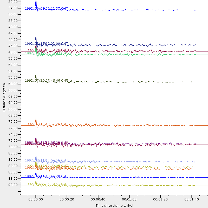
Events Processed for this Station
Download zip of receiver functions as SAC
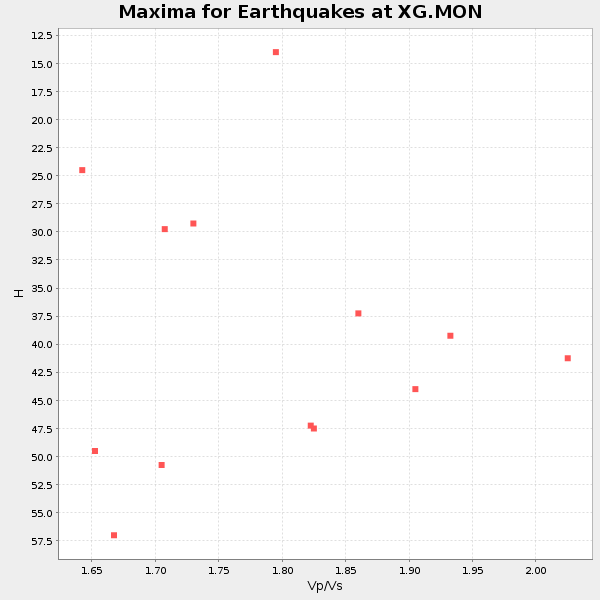
Plot maxima for each earthquake.
Events Used in the Stack
(13 events)| Radial Match | Distance | Baz | FERegion | Time | Lat/Lon | Depth | Magnitude |
| 95.74853 | 32.4 deg | 139.98 deg | Near Coast Of Nicaragua | 1992/09/02 00:15:57 GMT | (11.8, -87.4) | 10 km | 5.3 MB, 7.2 MS |
| 94.32148 | 89.5 deg | 240.828 deg | South Of Fiji Islands | 1992/07/11 10:44:20 GMT | (-22.3, -178.5) | 381 km | 6.2 MB |
| 93.294365 | 56.9 deg | 12.766 deg | Svalbard Region | 1992/07/20 07:46:46 GMT | (78.5, 5.1) | 10 km | 5.8 MB, 6.3 MS |
| 93.162224 | 86.0 deg | 309.796 deg | Southeast Of Honshu, Japan | 1992/08/29 19:19:07 GMT | (33.2, 138.0) | 309 km | 6.0 MB |
| 93.06324 | 47.6 deg | 307.3 deg | Andreanof Islands, Aleutian Is. | 1992/08/19 00:57:43 GMT | (50.5, -174.8) | 33 km | 6.1 MB, 5.7 MS, 5.6 ML |
| 92.337685 | 44.3 deg | 130.459 deg | Colombia | 1992/08/15 19:02:09 GMT | (5.1, -75.7) | 127 km | 5.7 MB |
| 91.83585 | 84.1 deg | 307.219 deg | Southeast Of Honshu, Japan | 1992/08/11 15:14:56 GMT | (32.5, 141.7) | 28 km | 5.8 MB, 6.2 MS |
| 90.80596 | 86.7 deg | 244.349 deg | Fiji Islands Region | 1992/08/30 20:09:06 GMT | (-17.7, -178.8) | 573 km | 5.8 MB |
| 90.6682 | 78.0 deg | 313.741 deg | Hokkaido, Japan Region | 1992/07/12 11:08:56 GMT | (41.4, 142.1) | 70 km | 5.9 MB |
| 89.22859 | 71.7 deg | 312.808 deg | Kuril Islands | 1992/07/10 09:31:26 GMT | (44.7, 149.5) | 11 km | 6.1 MB, 6.5 MS |
| 86.46257 | 92.2 deg | 235.508 deg | Kermadec Islands Region | 1992/06/25 06:30:51 GMT | (-28.1, -176.7) | 18 km | 6.1 MB, 6.5 MS |
| 84.63227 | 78.4 deg | 314.794 deg | Hokkaido, Japan Region | 1992/08/24 06:59:40 GMT | (41.9, 140.7) | 127 km | 6.2 MB |
| 80.59162 | 46.5 deg | 308.405 deg | Andreanof Islands, Aleutian Is. | 1992/06/24 12:11:26 GMT | (51.5, -173.4) | 33 km | 5.7 MB, 5.4 MS, 5.7 ML |
Losers
(0 events)| Radial Match | Distance | Baz | FERegion | Time | Lat/Lon | Depth | Magnitude | Reason |
