You are here: Home > Network List > XG92 - Rocky Mountain Front Stations List
> Station MON Montrose, CO > Earthquake Result Viewer
MON Montrose, CO - Earthquake Result Viewer
| Earthquake location: |
Colombia |
| Earthquake latitude/longitude: |
5.1/-75.7 |
| Earthquake time(UTC): |
1992/08/15 (228) 19:02:09 GMT |
| Earthquake Depth: |
127 km |
| Earthquake Magnitude: |
5.7 MB |
| Earthquake Catalog/Contributor: |
WHDF/NEIC |
|
| Network: |
XG Rocky Mountain Front |
| Station: |
MON Montrose, CO |
| Lat/Lon: |
38.53 N/108.00 W |
| Elevation: |
2097 m |
|
| Distance: |
44.3 deg |
| Az: |
323.196 deg |
| Baz: |
130.459 deg |
| Ray Param: |
0.0715302 |
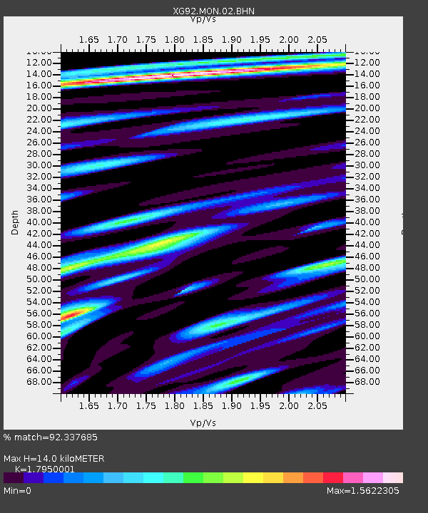
| Estimated Moho Depth: |
14.0 km |
| Estimated Crust Vp/Vs: |
1.80 |
| Assumed Crust Vp: |
6.306 km/s |
| Estimated Crust Vs: |
3.513 km/s |
| Estimated Crust Poisson's Ratio: |
0.27 |
|
| Radial Match: |
92.337685 % |
| Radial Bump: |
400 |
| Transverse Match: |
80.40692 % |
| Transverse Bump: |
400 |
| SOD ConfigId: |
3286 |
| Insert Time: |
2010-02-25 20:10:33.651 +0000 |
| GWidth: |
2.5 |
| Max Bumps: |
400 |
| Tol: |
0.001 |
|
Signal To Noise
| Channel | StoN | STA | LTA |
| XG:MON:02:BHN:19920815T19:09:36.828015Z | 14.19076 | 8.134067E-4 | 5.7319463E-5 |
| XG:MON:02:BHE:19920815T19:09:36.828015Z | 16.531277 | 8.1659126E-4 | 4.9396745E-5 |
| XG:MON:02:BHZ:19920815T19:09:36.828015Z | 22.501686 | 0.001501408 | 6.672424E-5 |
| Arrivals |
| Ps | 1.9 SECOND |
| PpPs | 5.8 SECOND |
| PsPs/PpSs | 7.7 SECOND |


