You are here: Home > Network List > XG92 - Rocky Mountain Front Stations List
> Station MON Montrose, CO > Earthquake Result Viewer
MON Montrose, CO - Earthquake Result Viewer
| Earthquake location: |
South Of Fiji Islands |
| Earthquake latitude/longitude: |
-22.3/-178.5 |
| Earthquake time(UTC): |
1992/07/11 (193) 10:44:20 GMT |
| Earthquake Depth: |
381 km |
| Earthquake Magnitude: |
6.2 MB |
| Earthquake Catalog/Contributor: |
WHDF/NEIC |
|
| Network: |
XG Rocky Mountain Front |
| Station: |
MON Montrose, CO |
| Lat/Lon: |
38.53 N/108.00 W |
| Elevation: |
2097 m |
|
| Distance: |
89.5 deg |
| Az: |
47.68 deg |
| Baz: |
240.828 deg |
| Ray Param: |
0.041646183 |
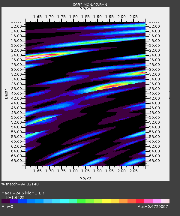
| Estimated Moho Depth: |
24.5 km |
| Estimated Crust Vp/Vs: |
1.64 |
| Assumed Crust Vp: |
6.306 km/s |
| Estimated Crust Vs: |
3.839 km/s |
| Estimated Crust Poisson's Ratio: |
0.21 |
|
| Radial Match: |
94.32148 % |
| Radial Bump: |
400 |
| Transverse Match: |
85.23218 % |
| Transverse Bump: |
400 |
| SOD ConfigId: |
3286 |
| Insert Time: |
2010-02-25 20:10:39.725 +0000 |
| GWidth: |
2.5 |
| Max Bumps: |
400 |
| Tol: |
0.001 |
|
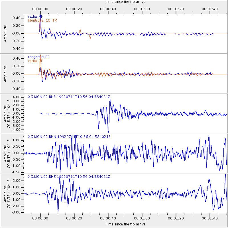
Signal To Noise
| Channel | StoN | STA | LTA |
| XG:MON:02:BHN:19920711T10:56:04.584021Z | 3.639326 | 2.157386E-4 | 5.9279824E-5 |
| XG:MON:02:BHE:19920711T10:56:04.584021Z | 11.993921 | 3.9439715E-4 | 3.2883087E-5 |
| XG:MON:02:BHZ:19920711T10:56:04.584021Z | 19.1313 | 0.0011403773 | 5.9607934E-5 |
| Arrivals |
| Ps | 2.6 SECOND |
| PpPs | 10 SECOND |
| PsPs/PpSs | 13 SECOND |


