You are here: Home > Network List > XG92 - Rocky Mountain Front Stations List
> Station MON Montrose, CO > Earthquake Result Viewer
MON Montrose, CO - Earthquake Result Viewer
| Earthquake location: |
Kuril Islands |
| Earthquake latitude/longitude: |
44.7/149.5 |
| Earthquake time(UTC): |
1992/07/10 (192) 09:31:26 GMT |
| Earthquake Depth: |
11 km |
| Earthquake Magnitude: |
6.1 MB, 6.5 MS |
| Earthquake Catalog/Contributor: |
WHDF/NEIC |
|
| Network: |
XG Rocky Mountain Front |
| Station: |
MON Montrose, CO |
| Lat/Lon: |
38.53 N/108.00 W |
| Elevation: |
2097 m |
|
| Distance: |
71.7 deg |
| Az: |
53.741 deg |
| Baz: |
312.808 deg |
| Ray Param: |
0.05413021 |
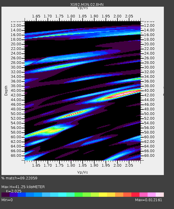
| Estimated Moho Depth: |
41.25 km |
| Estimated Crust Vp/Vs: |
2.03 |
| Assumed Crust Vp: |
6.306 km/s |
| Estimated Crust Vs: |
3.114 km/s |
| Estimated Crust Poisson's Ratio: |
0.34 |
|
| Radial Match: |
89.22859 % |
| Radial Bump: |
400 |
| Transverse Match: |
82.49686 % |
| Transverse Bump: |
400 |
| SOD ConfigId: |
3286 |
| Insert Time: |
2010-02-25 20:10:41.253 +0000 |
| GWidth: |
2.5 |
| Max Bumps: |
400 |
| Tol: |
0.001 |
|

Signal To Noise
| Channel | StoN | STA | LTA |
| XG:MON:02:BHN:19920710T09:42:16.78302Z | 1.5278528 | 2.0197776E-4 | 1.3219714E-4 |
| XG:MON:02:BHE:19920710T09:42:16.78302Z | 1.2931416 | 1.12927075E-4 | 8.7327695E-5 |
| XG:MON:02:BHZ:19920710T09:42:16.78302Z | 5.3935523 | 3.5683604E-4 | 6.6159744E-5 |
| Arrivals |
| Ps | 6.9 SECOND |
| PpPs | 19 SECOND |
| PsPs/PpSs | 26 SECOND |


