You are here: Home > Network List > XG92 - Rocky Mountain Front Stations List
> Station MON Montrose, CO > Earthquake Result Viewer
MON Montrose, CO - Earthquake Result Viewer
| Earthquake location: |
Andreanof Islands, Aleutian Is. |
| Earthquake latitude/longitude: |
51.5/-173.4 |
| Earthquake time(UTC): |
1992/06/24 (176) 12:11:26 GMT |
| Earthquake Depth: |
33 km |
| Earthquake Magnitude: |
5.7 MB, 5.4 MS, 5.7 ML |
| Earthquake Catalog/Contributor: |
WHDF/NEIC |
|
| Network: |
XG Rocky Mountain Front |
| Station: |
MON Montrose, CO |
| Lat/Lon: |
38.53 N/108.00 W |
| Elevation: |
2097 m |
|
| Distance: |
46.5 deg |
| Az: |
79.461 deg |
| Baz: |
308.405 deg |
| Ray Param: |
0.07055532 |
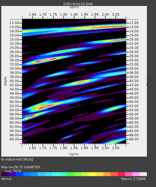
| Estimated Moho Depth: |
29.75 km |
| Estimated Crust Vp/Vs: |
1.71 |
| Assumed Crust Vp: |
6.306 km/s |
| Estimated Crust Vs: |
3.693 km/s |
| Estimated Crust Poisson's Ratio: |
0.24 |
|
| Radial Match: |
80.59162 % |
| Radial Bump: |
400 |
| Transverse Match: |
79.26992 % |
| Transverse Bump: |
400 |
| SOD ConfigId: |
3286 |
| Insert Time: |
2010-02-25 20:10:43.857 +0000 |
| GWidth: |
2.5 |
| Max Bumps: |
400 |
| Tol: |
0.001 |
|

Signal To Noise
| Channel | StoN | STA | LTA |
| XG:MON:02:BHN:19920624T12:19:19.511011Z | 1.81267 | 6.790424E-5 | 3.7460897E-5 |
| XG:MON:02:BHE:19920624T12:19:19.511011Z | 1.5508509 | 7.365724E-5 | 4.7494726E-5 |
| XG:MON:02:BHZ:19920624T12:19:19.511011Z | 2.2325766 | 1.4856519E-4 | 6.654427E-5 |
| Arrivals |
| Ps | 3.6 SECOND |
| PpPs | 12 SECOND |
| PsPs/PpSs | 16 SECOND |


