You are here: Home > Network List > TA - USArray Transportable Network (new EarthScope stations) Stations List
> Station 541A Lake Charles, LA, USA > Earthquake Result Viewer
541A Lake Charles, LA, USA - Earthquake Result Viewer
| Earthquake location: |
Near East Coast Of Honshu, Japan |
| Earthquake latitude/longitude: |
35.7/140.9 |
| Earthquake time(UTC): |
2011/03/11 (070) 06:57:16 GMT |
| Earthquake Depth: |
48 km |
| Earthquake Magnitude: |
6.0 MB |
| Earthquake Catalog/Contributor: |
WHDF/NEIC |
|
| Network: |
TA USArray Transportable Network (new EarthScope stations) |
| Station: |
541A Lake Charles, LA, USA |
| Lat/Lon: |
30.06 N/93.19 W |
| Elevation: |
0.0 m |
|
| Distance: |
97.1 deg |
| Az: |
45.027 deg |
| Baz: |
318.389 deg |
| Ray Param: |
0.040271766 |
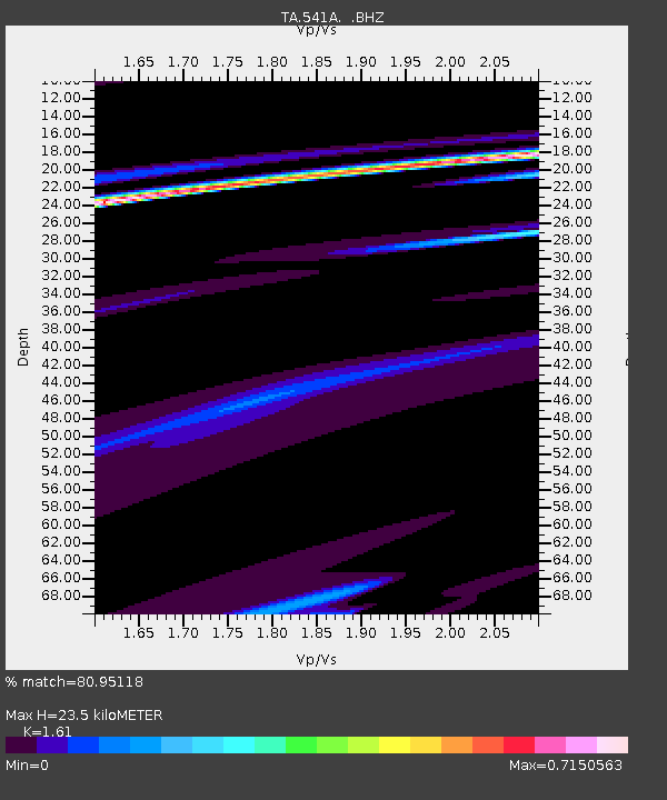
| Estimated Moho Depth: |
23.5 km |
| Estimated Crust Vp/Vs: |
1.61 |
| Assumed Crust Vp: |
6.065 km/s |
| Estimated Crust Vs: |
3.767 km/s |
| Estimated Crust Poisson's Ratio: |
0.19 |
|
| Radial Match: |
80.95118 % |
| Radial Bump: |
200 |
| Transverse Match: |
49.901337 % |
| Transverse Bump: |
400 |
| SOD ConfigId: |
356183 |
| Insert Time: |
2011-08-11 04:40:55.116 +0000 |
| GWidth: |
2.5 |
| Max Bumps: |
400 |
| Tol: |
0.001 |
|
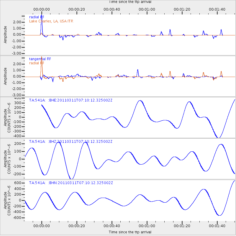
Signal To Noise
| Channel | StoN | STA | LTA |
| TA:541A: :BHZ:20110311T07:10:12.325002Z | 2.3565605 | 1.6887745E-4 | 7.166269E-5 |
| TA:541A: :BHN:20110311T07:10:12.325002Z | 1.0713416 | 2.2116148E-4 | 2.0643414E-4 |
| TA:541A: :BHE:20110311T07:10:12.325002Z | 0.40301248 | 4.8863163E-5 | 1.2124479E-4 |
| Arrivals |
| Ps | 2.4 SECOND |
| PpPs | 9.9 SECOND |
| PsPs/PpSs | 12 SECOND |


