You are here: Home > Network List > TA - USArray Transportable Network (new EarthScope stations) Stations List
> Station 541A Lake Charles, LA, USA > Earthquake Result Viewer
541A Lake Charles, LA, USA - Earthquake Result Viewer
| Earthquake location: |
Off East Coast Of Honshu, Japan |
| Earthquake latitude/longitude: |
37.4/144.7 |
| Earthquake time(UTC): |
2011/03/11 (070) 06:59:00 GMT |
| Earthquake Depth: |
36 km |
| Earthquake Magnitude: |
6.3 MB |
| Earthquake Catalog/Contributor: |
WHDF/NEIC |
|
| Network: |
TA USArray Transportable Network (new EarthScope stations) |
| Station: |
541A Lake Charles, LA, USA |
| Lat/Lon: |
30.06 N/93.19 W |
| Elevation: |
0.0 m |
|
| Distance: |
93.8 deg |
| Az: |
47.402 deg |
| Baz: |
317.424 deg |
| Ray Param: |
0.04118154 |
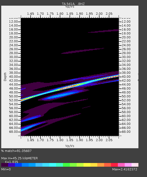
| Estimated Moho Depth: |
45.25 km |
| Estimated Crust Vp/Vs: |
1.84 |
| Assumed Crust Vp: |
6.065 km/s |
| Estimated Crust Vs: |
3.305 km/s |
| Estimated Crust Poisson's Ratio: |
0.29 |
|
| Radial Match: |
91.05687 % |
| Radial Bump: |
193 |
| Transverse Match: |
95.29948 % |
| Transverse Bump: |
208 |
| SOD ConfigId: |
356183 |
| Insert Time: |
2011-08-11 06:13:01.197 +0000 |
| GWidth: |
2.5 |
| Max Bumps: |
400 |
| Tol: |
0.001 |
|

Signal To Noise
| Channel | StoN | STA | LTA |
| TA:541A: :BHZ:20110311T07:11:42.175029Z | 2.627375 | 1.1852354E-4 | 4.5111014E-5 |
| TA:541A: :BHN:20110311T07:11:42.175029Z | 2.983283 | 3.8146088E-4 | 1.2786614E-4 |
| TA:541A: :BHE:20110311T07:11:42.175029Z | 1.441737 | 4.2459188E-4 | 2.945002E-4 |
| Arrivals |
| Ps | 6.3 SECOND |
| PpPs | 21 SECOND |
| PsPs/PpSs | 27 SECOND |


