You are here: Home > Network List > XG92 - Rocky Mountain Front Stations List
> Station PAR Paradox, CO > Earthquake Result Viewer
PAR Paradox, CO - Earthquake Result Viewer
| Earthquake location: |
Andreanof Islands, Aleutian Is. |
| Earthquake latitude/longitude: |
50.5/-174.8 |
| Earthquake time(UTC): |
1992/08/19 (232) 00:57:43 GMT |
| Earthquake Depth: |
33 km |
| Earthquake Magnitude: |
6.1 MB, 5.7 MS, 5.6 ML |
| Earthquake Catalog/Contributor: |
WHDF/NEIC |
|
| Network: |
XG Rocky Mountain Front |
| Station: |
PAR Paradox, CO |
| Lat/Lon: |
38.35 N/108.98 W |
| Elevation: |
1810 m |
|
| Distance: |
47.1 deg |
| Az: |
78.388 deg |
| Baz: |
307.254 deg |
| Ray Param: |
0.07014998 |
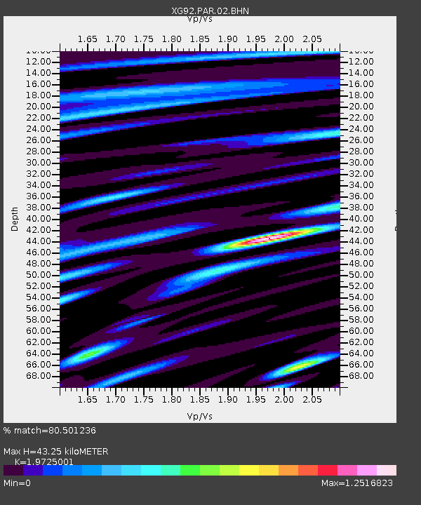
| Estimated Moho Depth: |
43.25 km |
| Estimated Crust Vp/Vs: |
1.97 |
| Assumed Crust Vp: |
6.291 km/s |
| Estimated Crust Vs: |
3.189 km/s |
| Estimated Crust Poisson's Ratio: |
0.33 |
|
| Radial Match: |
80.501236 % |
| Radial Bump: |
400 |
| Transverse Match: |
68.581055 % |
| Transverse Bump: |
400 |
| SOD ConfigId: |
3286 |
| Insert Time: |
2010-02-25 20:10:51.733 +0000 |
| GWidth: |
2.5 |
| Max Bumps: |
400 |
| Tol: |
0.001 |
|

Signal To Noise
| Channel | StoN | STA | LTA |
| XG:PAR:02:BHN:19920819T01:05:41.813013Z | 3.711493 | 2.9786513E-4 | 8.02548E-5 |
| XG:PAR:02:BHE:19920819T01:05:41.813013Z | 5.740069 | 3.546352E-4 | 6.17824E-5 |
| XG:PAR:02:BHZ:19920819T01:05:41.813013Z | 12.65442 | 0.0010632314 | 8.4020554E-5 |
| Arrivals |
| Ps | 7.0 SECOND |
| PpPs | 19 SECOND |
| PsPs/PpSs | 26 SECOND |


