
Station XG PAR - Paradox, CO
Network: XG92 - Rocky Mountain Front
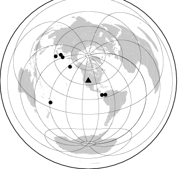
Nearby stations (2 deg radius)
| Station | Name | (Lat, Lon) | Start / End | Elevation |
| PAR | Paradox, CO | (38.35, -108.98) | 1992-05-23 / 2499-01-01 | 1.8 km |
| Crust2 Type: | Q3,orogen/43km no ice, Appalachians, 3 km seds. |
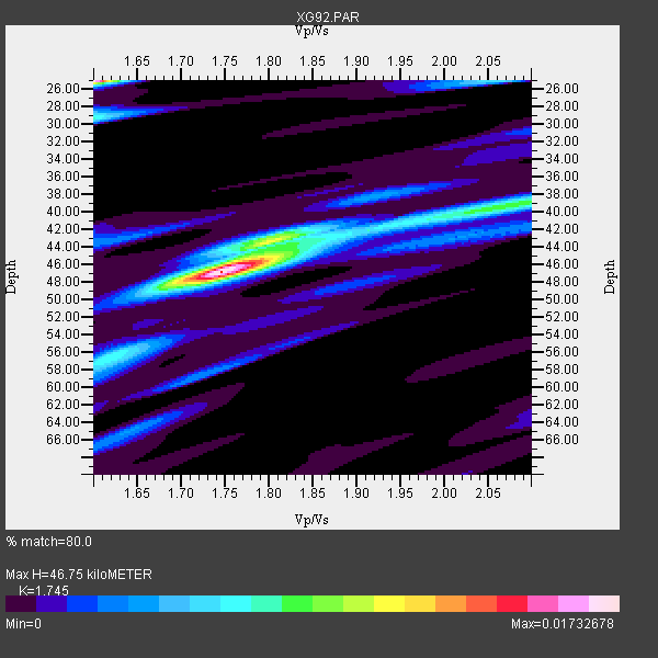
| Thickness Estimate: | 47 km |
| Thickness StdDev: | 11 km |
| Vp/Vs Estimate: | 1.75 |
| Vp/Vs StdDev: | 0.17 |
| Vs Estimate: | 3.605 km/s |
| Poisson's Ratio: | 0.26 |
| Peak Value: | 0.02 |
| Assumed Vp: | 6.291 km/s |
| Ps Weight: | 0.33333334 |
| PpPs Weight: | 0.33333334 |
| PsPs Weight: | 0.33333328 |
| Residual Complexity: | 0.554 |
| Nearby stations H: | +- |
| (2.0 deg) Vp/Vs: | +- |
2 with match > 90% ( 28.571428 %) and 7 with match > 80% ( 100.0 %) out of 7.
Download stack as xyz text file.
Azimuth Distribution of Events:
Prior Results for this Station
| Study | Thickness | Vp/Vs | Vp | Vs | Poissons Ratio | Extra |
| EARS | 47 km | 1.75 | 6.291 km/s | 3.605 km/s | 0.26 | |
| Crust2.0 | 43 km | 1.76 | 6.291 km/s | 3.577 km/s | 0.26 | Q3,orogen/43km no ice, Appalachians, 3 km seds. |
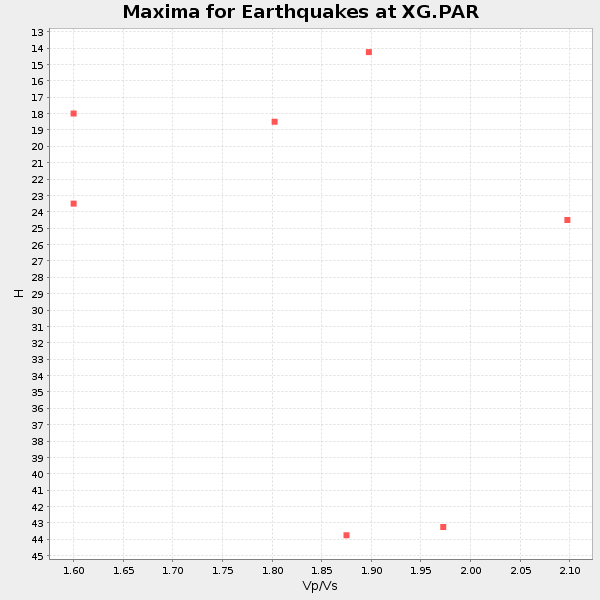
| Global Maxima | 47 km | 1.75 | 6.291 km/s | 3.605 km/s | 0.26 | amp=0.01732678 |
| Local Maxima 1 | 25 km | 1.60 | 6.291 km/s | 3.932 km/s | 0.18 | amp=0.016574683 |
| Local Maxima 2 | 43 km | 1.80 | 6.291 km/s | 3.49 km/s | 0.28 | amp=0.00802797 |
| Local Maxima 3 | 29 km | 1.60 | 6.291 km/s | 3.932 km/s | 0.18 | amp=0.0069522555 |
| Local Maxima 4 | 39 km | 2.08 | 6.291 km/s | 3.032 km/s | 0.35 | amp=0.00642737 |
| Predicted Arrivals for vertical incidence (zero ray parameter) | |
| Ps | 5.54 SECOND |
| PpPs | 20.40 SECOND |
| PsPs/PpSs | 25.94 SECOND |
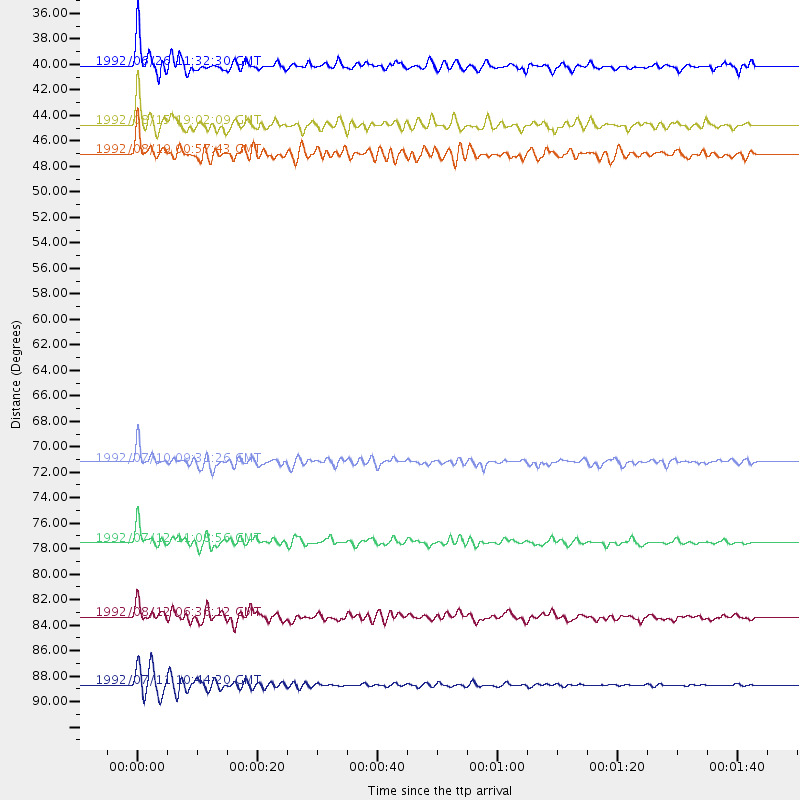
Events Processed for this Station
Download zip of receiver functions as SAC
Plot maxima for each earthquake.
Events Used in the Stack
(7 events)| Radial Match | Distance | Baz | FERegion | Time | Lat/Lon | Depth | Magnitude |
| 92.22762 | 77.6 deg | 313.275 deg | Hokkaido, Japan Region | 1992/07/12 11:08:56 GMT | (41.4, 142.1) | 70 km | 5.9 MB |
| 91.35447 | 71.3 deg | 312.418 deg | Kuril Islands | 1992/07/10 09:31:26 GMT | (44.7, 149.5) | 11 km | 6.1 MB, 6.5 MS |
| 89.275314 | 83.4 deg | 306.827 deg | Southeast Of Honshu, Japan | 1992/08/12 06:36:12 GMT | (32.8, 141.8) | 33 km | 5.5 MB, 5.6 MS |
| 89.12921 | 40.1 deg | 136.287 deg | South Of Panama | 1992/06/26 11:32:30 GMT | (6.1, -82.4) | 33 km | 5.8 MB, 5.4 MS |
| 85.783104 | 88.8 deg | 240.215 deg | South Of Fiji Islands | 1992/07/11 10:44:20 GMT | (-22.3, -178.5) | 381 km | 6.2 MB |
| 82.58001 | 44.8 deg | 129.205 deg | Colombia | 1992/08/15 19:02:09 GMT | (5.1, -75.7) | 127 km | 5.7 MB |
| 80.501236 | 47.1 deg | 307.254 deg | Andreanof Islands, Aleutian Is. | 1992/08/19 00:57:43 GMT | (50.5, -174.8) | 33 km | 6.1 MB, 5.7 MS, 5.6 ML |
Losers
(0 events)| Radial Match | Distance | Baz | FERegion | Time | Lat/Lon | Depth | Magnitude | Reason |
