You are here: Home > Network List > XG92 - Rocky Mountain Front Stations List
> Station PAR Paradox, CO > Earthquake Result Viewer
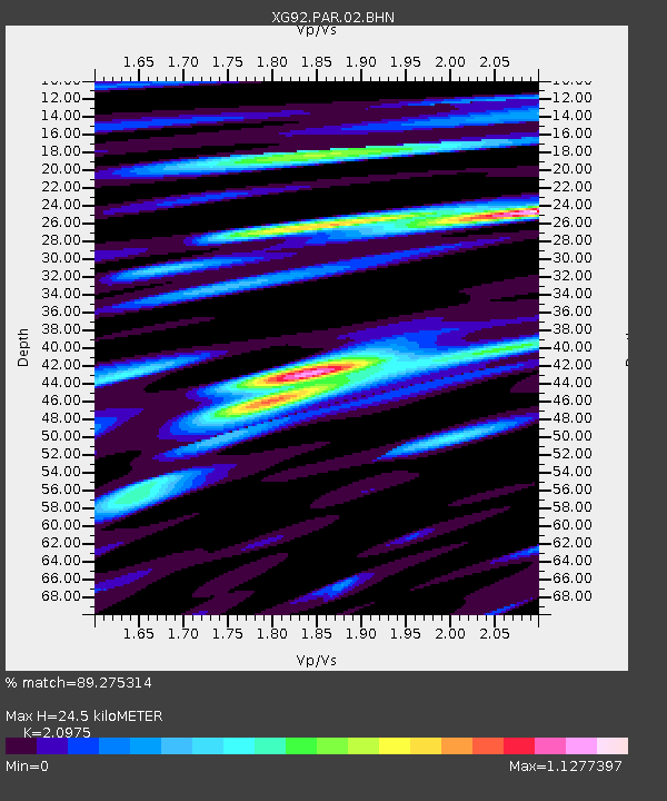
PAR Paradox, CO - Earthquake Result Viewer
| Earthquake location: |
Southeast Of Honshu, Japan |
| Earthquake latitude/longitude: |
32.8/141.8 |
| Earthquake time(UTC): |
1992/08/12 (225) 06:36:12 GMT |
| Earthquake Depth: |
33 km |
| Earthquake Magnitude: |
5.5 MB, 5.6 MS |
| Earthquake Catalog/Contributor: |
WHDF/NEIC |
|
| Network: |
XG Rocky Mountain Front |
| Station: |
PAR Paradox, CO |
| Lat/Lon: |
38.35 N/108.98 W |
| Elevation: |
1810 m |
|
| Distance: |
83.4 deg |
| Az: |
48.351 deg |
| Baz: |
306.827 deg |
| Ray Param: |
0.046164192 |
| Estimated Moho Depth: |
24.5 km |
| Estimated Crust Vp/Vs: |
2.10 |
| Assumed Crust Vp: |
6.291 km/s |
| Estimated Crust Vs: |
2.999 km/s |
| Estimated Crust Poisson's Ratio: |
0.35 |
|
| Radial Match: |
89.275314 % |
| Radial Bump: |
400 |
| Transverse Match: |
86.00689 % |
| Transverse Bump: |
400 |
| SOD ConfigId: |
3286 |
| Insert Time: |
2010-02-25 20:10:56.300 +0000 |
| GWidth: |
2.5 |
| Max Bumps: |
400 |
| Tol: |
0.001 |
|

Signal To Noise
| Channel | StoN | STA | LTA |
| XG:PAR:02:BHN:19920812T06:48:05.214026Z | 0.88857925 | 5.2394695E-5 | 5.896457E-5 |
| XG:PAR:02:BHE:19920812T06:48:05.214026Z | 1.2689466 | 6.383835E-5 | 5.0308143E-5 |
| XG:PAR:02:BHZ:19920812T06:48:05.214026Z | 2.1685343 | 1.6414117E-4 | 7.5692216E-5 |
| Arrivals |
| Ps | 4.4 SECOND |
| PpPs | 12 SECOND |
| PsPs/PpSs | 16 SECOND |


