You are here: Home > Network List > XG92 - Rocky Mountain Front Stations List
> Station PAR Paradox, CO > Earthquake Result Viewer
PAR Paradox, CO - Earthquake Result Viewer
| Earthquake location: |
Hokkaido, Japan Region |
| Earthquake latitude/longitude: |
41.4/142.1 |
| Earthquake time(UTC): |
1992/07/12 (194) 11:08:56 GMT |
| Earthquake Depth: |
70 km |
| Earthquake Magnitude: |
5.9 MB |
| Earthquake Catalog/Contributor: |
WHDF/NEIC |
|
| Network: |
XG Rocky Mountain Front |
| Station: |
PAR Paradox, CO |
| Lat/Lon: |
38.35 N/108.98 W |
| Elevation: |
1810 m |
|
| Distance: |
77.6 deg |
| Az: |
49.59 deg |
| Baz: |
313.275 deg |
| Ray Param: |
0.0500886 |
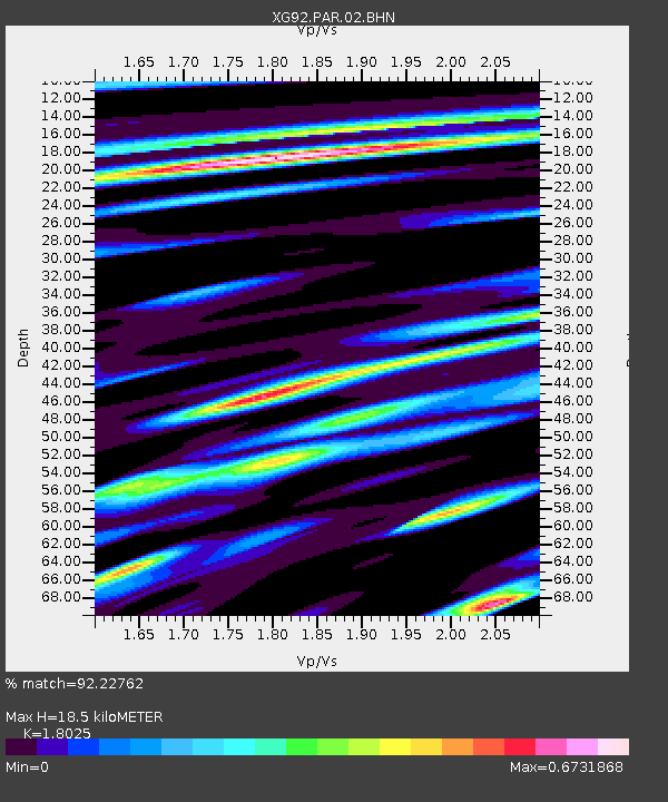
| Estimated Moho Depth: |
18.5 km |
| Estimated Crust Vp/Vs: |
1.80 |
| Assumed Crust Vp: |
6.291 km/s |
| Estimated Crust Vs: |
3.49 km/s |
| Estimated Crust Poisson's Ratio: |
0.28 |
|
| Radial Match: |
92.22762 % |
| Radial Bump: |
400 |
| Transverse Match: |
89.235 % |
| Transverse Bump: |
400 |
| SOD ConfigId: |
3286 |
| Insert Time: |
2010-02-25 20:10:57.975 +0000 |
| GWidth: |
2.5 |
| Max Bumps: |
400 |
| Tol: |
0.001 |
|

Signal To Noise
| Channel | StoN | STA | LTA |
| XG:PAR:02:BHN:19920712T11:20:13.442017Z | 1.4262016 | 1.0510561E-4 | 7.369618E-5 |
| XG:PAR:02:BHE:19920712T11:20:13.442017Z | 2.6910636 | 1.7146331E-4 | 6.3715815E-5 |
| XG:PAR:02:BHZ:19920712T11:20:13.442017Z | 9.348966 | 6.3275156E-4 | 6.768145E-5 |
| Arrivals |
| Ps | 2.4 SECOND |
| PpPs | 8.0 SECOND |
| PsPs/PpSs | 10 SECOND |


