You are here: Home > Network List > XG92 - Rocky Mountain Front Stations List
> Station PAR Paradox, CO > Earthquake Result Viewer
PAR Paradox, CO - Earthquake Result Viewer
| Earthquake location: |
South Of Fiji Islands |
| Earthquake latitude/longitude: |
-22.3/-178.5 |
| Earthquake time(UTC): |
1992/07/11 (193) 10:44:20 GMT |
| Earthquake Depth: |
381 km |
| Earthquake Magnitude: |
6.2 MB |
| Earthquake Catalog/Contributor: |
WHDF/NEIC |
|
| Network: |
XG Rocky Mountain Front |
| Station: |
PAR Paradox, CO |
| Lat/Lon: |
38.35 N/108.98 W |
| Elevation: |
1810 m |
|
| Distance: |
88.8 deg |
| Az: |
47.456 deg |
| Baz: |
240.215 deg |
| Ray Param: |
0.041700434 |
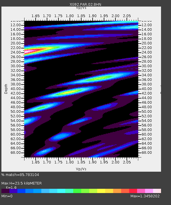
| Estimated Moho Depth: |
23.5 km |
| Estimated Crust Vp/Vs: |
1.60 |
| Assumed Crust Vp: |
6.291 km/s |
| Estimated Crust Vs: |
3.932 km/s |
| Estimated Crust Poisson's Ratio: |
0.18 |
|
| Radial Match: |
85.783104 % |
| Radial Bump: |
400 |
| Transverse Match: |
76.394226 % |
| Transverse Bump: |
400 |
| SOD ConfigId: |
3286 |
| Insert Time: |
2010-02-25 20:10:59.487 +0000 |
| GWidth: |
2.5 |
| Max Bumps: |
400 |
| Tol: |
0.001 |
|
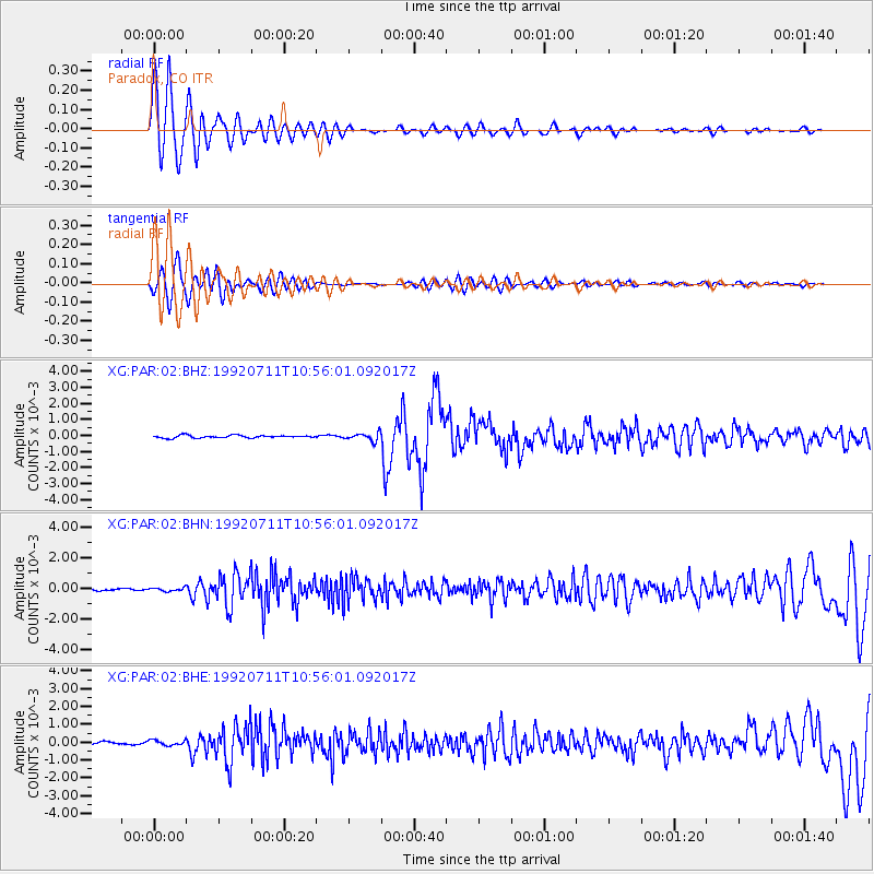
Signal To Noise
| Channel | StoN | STA | LTA |
| XG:PAR:02:BHN:19920711T10:56:01.092017Z | 1.1628505 | 1.0489719E-4 | 9.0206944E-5 |
| XG:PAR:02:BHE:19920711T10:56:01.092017Z | 2.1003752 | 1.4427923E-4 | 6.869213E-5 |
| XG:PAR:02:BHZ:19920711T10:56:01.092017Z | 2.865468 | 2.4021619E-4 | 8.383139E-5 |
| Arrivals |
| Ps | 2.3 SECOND |
| PpPs | 9.5 SECOND |
| PsPs/PpSs | 12 SECOND |


