You are here: Home > Network List > XG92 - Rocky Mountain Front Stations List
> Station PAR Paradox, CO > Earthquake Result Viewer
PAR Paradox, CO - Earthquake Result Viewer
| Earthquake location: |
Kuril Islands |
| Earthquake latitude/longitude: |
44.7/149.5 |
| Earthquake time(UTC): |
1992/07/10 (192) 09:31:26 GMT |
| Earthquake Depth: |
11 km |
| Earthquake Magnitude: |
6.1 MB, 6.5 MS |
| Earthquake Catalog/Contributor: |
WHDF/NEIC |
|
| Network: |
XG Rocky Mountain Front |
| Station: |
PAR Paradox, CO |
| Lat/Lon: |
38.35 N/108.98 W |
| Elevation: |
1810 m |
|
| Distance: |
71.3 deg |
| Az: |
54.434 deg |
| Baz: |
312.418 deg |
| Ray Param: |
0.054429363 |
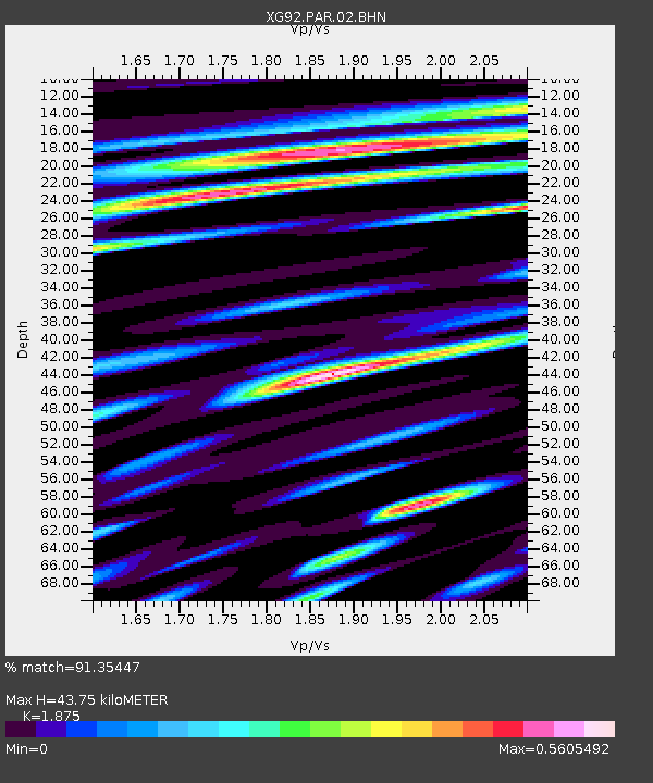
| Estimated Moho Depth: |
43.75 km |
| Estimated Crust Vp/Vs: |
1.88 |
| Assumed Crust Vp: |
6.291 km/s |
| Estimated Crust Vs: |
3.355 km/s |
| Estimated Crust Poisson's Ratio: |
0.30 |
|
| Radial Match: |
91.35447 % |
| Radial Bump: |
400 |
| Transverse Match: |
78.1412 % |
| Transverse Bump: |
400 |
| SOD ConfigId: |
3286 |
| Insert Time: |
2010-02-25 20:11:00.939 +0000 |
| GWidth: |
2.5 |
| Max Bumps: |
400 |
| Tol: |
0.001 |
|
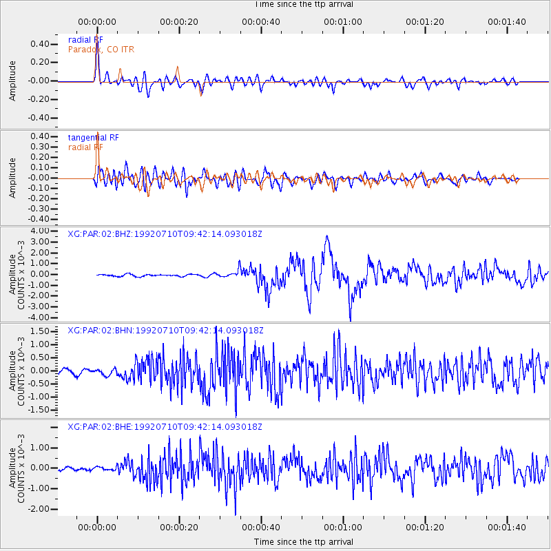
Signal To Noise
| Channel | StoN | STA | LTA |
| XG:PAR:02:BHN:19920710T09:42:14.093018Z | 1.4864862 | 1.1758994E-4 | 7.910597E-5 |
| XG:PAR:02:BHE:19920710T09:42:14.093018Z | 1.5860399 | 9.0073205E-5 | 5.679126E-5 |
| XG:PAR:02:BHZ:19920710T09:42:14.093018Z | 3.9741611 | 3.570517E-4 | 8.9843285E-5 |
| Arrivals |
| Ps | 6.3 SECOND |
| PpPs | 19 SECOND |
| PsPs/PpSs | 26 SECOND |


