You are here: Home > Network List > XG92 - Rocky Mountain Front Stations List
> Station PKS Palco, KS > Earthquake Result Viewer
PKS Palco, KS - Earthquake Result Viewer
| Earthquake location: |
Near Coast Of Nicaragua |
| Earthquake latitude/longitude: |
11.3/-86.8 |
| Earthquake time(UTC): |
1992/09/02 (246) 18:28:56 GMT |
| Earthquake Depth: |
10 km |
| Earthquake Magnitude: |
5.2 MB, 5.8 MS |
| Earthquake Catalog/Contributor: |
WHDF/NEIC |
|
| Network: |
XG Rocky Mountain Front |
| Station: |
PKS Palco, KS |
| Lat/Lon: |
39.26 N/99.54 W |
| Elevation: |
673 m |
|
| Distance: |
30.1 deg |
| Az: |
339.953 deg |
| Baz: |
154.336 deg |
| Ray Param: |
0.079422094 |
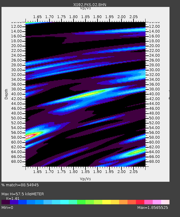
| Estimated Moho Depth: |
57.5 km |
| Estimated Crust Vp/Vs: |
1.61 |
| Assumed Crust Vp: |
6.483 km/s |
| Estimated Crust Vs: |
4.026 km/s |
| Estimated Crust Poisson's Ratio: |
0.19 |
|
| Radial Match: |
88.54945 % |
| Radial Bump: |
400 |
| Transverse Match: |
55.19571 % |
| Transverse Bump: |
400 |
| SOD ConfigId: |
3286 |
| Insert Time: |
2010-02-25 20:11:05.963 +0000 |
| GWidth: |
2.5 |
| Max Bumps: |
400 |
| Tol: |
0.001 |
|
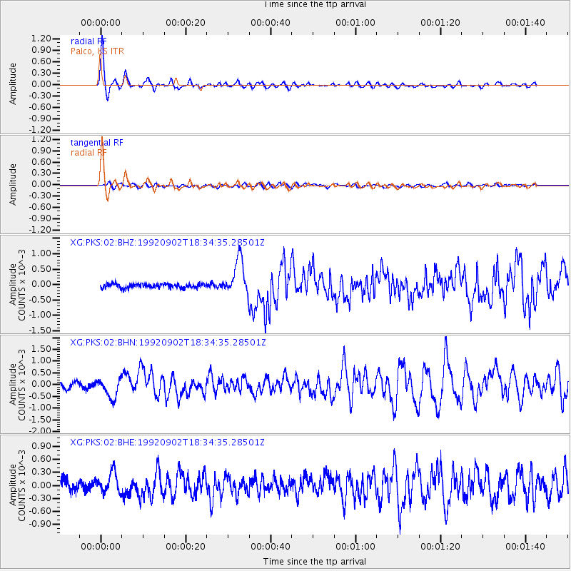
Signal To Noise
| Channel | StoN | STA | LTA |
| XG:PKS:02:BHN:19920902T18:34:35.28501Z | 3.6902404 | 4.104827E-4 | 1.1123468E-4 |
| XG:PKS:02:BHE:19920902T18:34:35.28501Z | 2.0652347 | 2.4820535E-4 | 1.20182645E-4 |
| XG:PKS:02:BHZ:19920902T18:34:35.28501Z | 9.08241 | 5.9622293E-4 | 6.5645894E-5 |
| Arrivals |
| Ps | 5.9 SECOND |
| PpPs | 21 SECOND |
| PsPs/PpSs | 27 SECOND |


