
Station XG PKS - Palco, KS
Network: XG92 - Rocky Mountain Front
Nearby stations (2 deg radius)
| Station | Name | (Lat, Lon) | Start / End | Elevation |
| PKS | Palco, KS | (39.26, -99.54) | 1992-05-23 / 2499-01-01 | 0.7 km |
| Crust2 Type: | D5,thick Platform 2 km seds. |
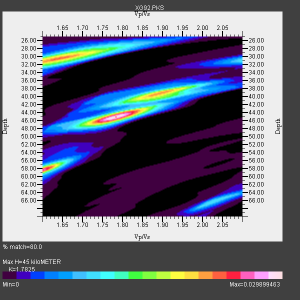
| Thickness Estimate: | 45 km |
| Thickness StdDev: | 9.0 km |
| Vp/Vs Estimate: | 1.78 |
| Vp/Vs StdDev: | 0.10 |
| Vs Estimate: | 3.637 km/s |
| Poisson's Ratio: | 0.27 |
| Peak Value: | 0.03 |
| Assumed Vp: | 6.483 km/s |
| Ps Weight: | 0.33333334 |
| PpPs Weight: | 0.33333334 |
| PsPs Weight: | 0.33333328 |
| Residual Complexity: | 0.728 |
| Nearby stations H: | +- |
| (2.0 deg) Vp/Vs: | +- |
4 with match > 90% ( 57.142857 %) and 7 with match > 80% ( 100.0 %) out of 7.
Download stack as xyz text file.
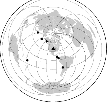
Azimuth Distribution of Events:
Prior Results for this Station
| Study | Thickness | Vp/Vs | Vp | Vs | Poissons Ratio | Extra |
| EARS | 45 km | 1.78 | 6.483 km/s | 3.637 km/s | 0.27 | |
| Crust2.0 | 46 km | 1.78 | 6.483 km/s | 3.648 km/s | 0.27 | D5,thick Platform 2 km seds. |
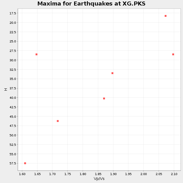
| Global Maxima | 45 km | 1.78 | 6.483 km/s | 3.637 km/s | 0.27 | amp=0.029899463 |
| Local Maxima 1 | 58 km | 1.60 | 6.483 km/s | 4.052 km/s | 0.18 | amp=0.02587298 |
| Local Maxima 2 | 30 km | 1.63 | 6.483 km/s | 3.965 km/s | 0.20 | amp=0.022968128 |
| Local Maxima 3 | 39 km | 1.90 | 6.483 km/s | 3.403 km/s | 0.31 | amp=0.01704304 |
| Local Maxima 4 | 28 km | 1.73 | 6.483 km/s | 3.753 km/s | 0.25 | amp=0.01022052 |
| Predicted Arrivals for vertical incidence (zero ray parameter) | |
| Ps | 5.43 SECOND |
| PpPs | 19.32 SECOND |
| PsPs/PpSs | 24.75 SECOND |
Events Processed for this Station
Download zip of receiver functions as SAC
Plot maxima for each earthquake.
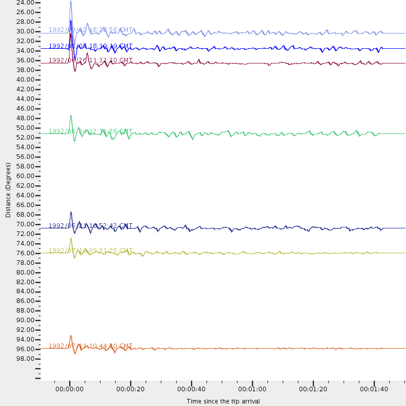
Events Used in the Stack
(7 events)| Radial Match | Distance | Baz | FERegion | Time | Lat/Lon | Depth | Magnitude |
| 95.05391 | 36.4 deg | 150.382 deg | South Of Panama | 1992/06/26 11:32:30 GMT | (6.1, -82.4) | 33 km | 5.8 MB, 5.4 MS |
| 94.70205 | 75.9 deg | 316.605 deg | Kuril Islands | 1992/07/10 09:31:26 GMT | (44.7, 149.5) | 11 km | 6.1 MB, 6.5 MS |
| 94.44153 | 95.7 deg | 246.017 deg | South Of Fiji Islands | 1992/07/11 10:44:20 GMT | (-22.3, -178.5) | 381 km | 6.2 MB |
| 93.7434 | 33.5 deg | 317.764 deg | Gulf Of Alaska | 1992/08/07 18:19:19 GMT | (57.6, -143.0) | 10 km | 6.3 MB, 6.5 MS, 6.5 ML |
| 88.54945 | 30.1 deg | 154.336 deg | Near Coast Of Nicaragua | 1992/09/02 18:28:56 GMT | (11.3, -86.8) | 10 km | 5.2 MB, 5.8 MS |
| 88.51084 | 70.8 deg | 152.699 deg | Near Coast Of Northern Chile | 1992/06/21 10:52:42 GMT | (-26.5, -70.6) | 39 km | 5.6 MB, 5.3 MS |
| 87.89872 | 51.2 deg | 309.571 deg | Andreanof Islands, Aleutian Is. | 1992/06/24 12:11:26 GMT | (51.5, -173.4) | 33 km | 5.7 MB, 5.4 MS, 5.7 ML |
Losers
(0 events)| Radial Match | Distance | Baz | FERegion | Time | Lat/Lon | Depth | Magnitude | Reason |
