You are here: Home > Network List > XG92 - Rocky Mountain Front Stations List
> Station PKS Palco, KS > Earthquake Result Viewer
PKS Palco, KS - Earthquake Result Viewer
| Earthquake location: |
Gulf Of Alaska |
| Earthquake latitude/longitude: |
57.6/-143.0 |
| Earthquake time(UTC): |
1992/08/07 (220) 18:19:19 GMT |
| Earthquake Depth: |
10 km |
| Earthquake Magnitude: |
6.3 MB, 6.5 MS, 6.5 ML |
| Earthquake Catalog/Contributor: |
WHDF/NEIC |
|
| Network: |
XG Rocky Mountain Front |
| Station: |
PKS Palco, KS |
| Lat/Lon: |
39.26 N/99.54 W |
| Elevation: |
673 m |
|
| Distance: |
33.5 deg |
| Az: |
104.204 deg |
| Baz: |
317.764 deg |
| Ray Param: |
0.07819816 |
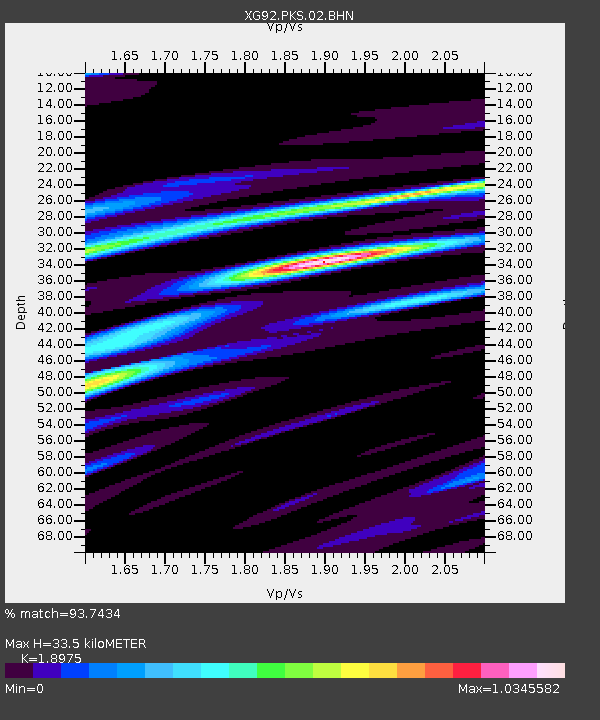
| Estimated Moho Depth: |
33.5 km |
| Estimated Crust Vp/Vs: |
1.90 |
| Assumed Crust Vp: |
6.483 km/s |
| Estimated Crust Vs: |
3.416 km/s |
| Estimated Crust Poisson's Ratio: |
0.31 |
|
| Radial Match: |
93.7434 % |
| Radial Bump: |
276 |
| Transverse Match: |
71.41483 % |
| Transverse Bump: |
400 |
| SOD ConfigId: |
3286 |
| Insert Time: |
2010-02-25 20:11:07.471 +0000 |
| GWidth: |
2.5 |
| Max Bumps: |
400 |
| Tol: |
0.001 |
|
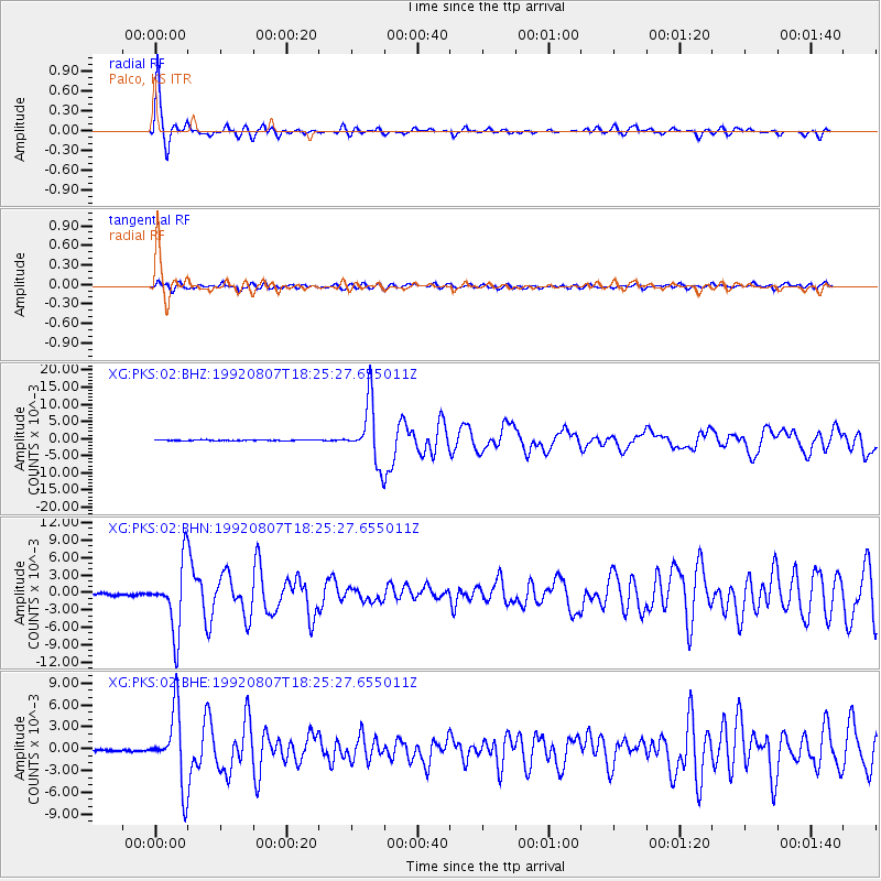
Signal To Noise
| Channel | StoN | STA | LTA |
| XG:PKS:02:BHN:19920807T18:25:27.655011Z | 34.550613 | 0.005854223 | 1.6943904E-4 |
| XG:PKS:02:BHE:19920807T18:25:27.655011Z | 39.22236 | 0.0049967472 | 1.2739538E-4 |
| XG:PKS:02:BHZ:19920807T18:25:27.655011Z | 84.92476 | 0.008777514 | 1.0335637E-4 |
| Arrivals |
| Ps | 5.0 SECOND |
| PpPs | 14 SECOND |
| PsPs/PpSs | 19 SECOND |


