You are here: Home > Network List > XG92 - Rocky Mountain Front Stations List
> Station PKS Palco, KS > Earthquake Result Viewer
PKS Palco, KS - Earthquake Result Viewer
| Earthquake location: |
Kuril Islands |
| Earthquake latitude/longitude: |
44.7/149.5 |
| Earthquake time(UTC): |
1992/07/10 (192) 09:31:26 GMT |
| Earthquake Depth: |
11 km |
| Earthquake Magnitude: |
6.1 MB, 6.5 MS |
| Earthquake Catalog/Contributor: |
WHDF/NEIC |
|
| Network: |
XG Rocky Mountain Front |
| Station: |
PKS Palco, KS |
| Lat/Lon: |
39.26 N/99.54 W |
| Elevation: |
673 m |
|
| Distance: |
75.9 deg |
| Az: |
48.375 deg |
| Baz: |
316.605 deg |
| Ray Param: |
0.051345464 |
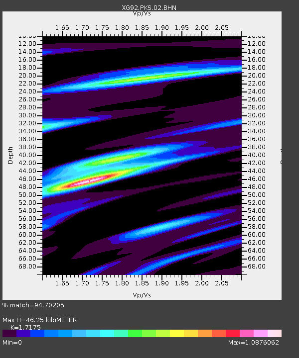
| Estimated Moho Depth: |
46.25 km |
| Estimated Crust Vp/Vs: |
1.72 |
| Assumed Crust Vp: |
6.483 km/s |
| Estimated Crust Vs: |
3.774 km/s |
| Estimated Crust Poisson's Ratio: |
0.24 |
|
| Radial Match: |
94.70205 % |
| Radial Bump: |
311 |
| Transverse Match: |
79.21552 % |
| Transverse Bump: |
400 |
| SOD ConfigId: |
3286 |
| Insert Time: |
2010-02-25 20:11:09.740 +0000 |
| GWidth: |
2.5 |
| Max Bumps: |
400 |
| Tol: |
0.001 |
|
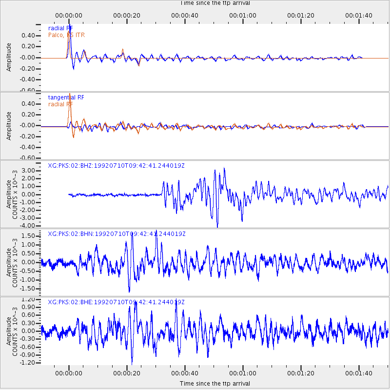
Signal To Noise
| Channel | StoN | STA | LTA |
| XG:PKS:02:BHN:19920710T09:42:41.244019Z | 1.913677 | 2.492538E-4 | 1.3024862E-4 |
| XG:PKS:02:BHE:19920710T09:42:41.244019Z | 1.5964594 | 2.0324165E-4 | 1.2730775E-4 |
| XG:PKS:02:BHZ:19920710T09:42:41.244019Z | 8.693967 | 6.8065757E-4 | 7.8290795E-5 |
| Arrivals |
| Ps | 5.3 SECOND |
| PpPs | 19 SECOND |
| PsPs/PpSs | 24 SECOND |


