You are here: Home > Network List > XG92 - Rocky Mountain Front Stations List
> Station PKS Palco, KS > Earthquake Result Viewer
PKS Palco, KS - Earthquake Result Viewer
| Earthquake location: |
South Of Panama |
| Earthquake latitude/longitude: |
6.1/-82.4 |
| Earthquake time(UTC): |
1992/06/26 (178) 11:32:30 GMT |
| Earthquake Depth: |
33 km |
| Earthquake Magnitude: |
5.8 MB, 5.4 MS |
| Earthquake Catalog/Contributor: |
WHDF/NEIC |
|
| Network: |
XG Rocky Mountain Front |
| Station: |
PKS Palco, KS |
| Lat/Lon: |
39.26 N/99.54 W |
| Elevation: |
673 m |
|
| Distance: |
36.4 deg |
| Az: |
337.301 deg |
| Baz: |
150.382 deg |
| Ray Param: |
0.07661566 |
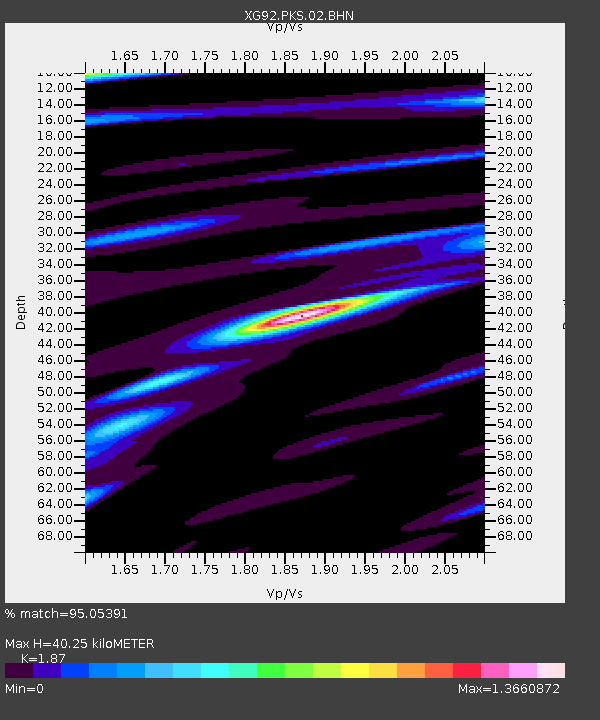
| Estimated Moho Depth: |
40.25 km |
| Estimated Crust Vp/Vs: |
1.87 |
| Assumed Crust Vp: |
6.483 km/s |
| Estimated Crust Vs: |
3.467 km/s |
| Estimated Crust Poisson's Ratio: |
0.30 |
|
| Radial Match: |
95.05391 % |
| Radial Bump: |
263 |
| Transverse Match: |
81.937874 % |
| Transverse Bump: |
400 |
| SOD ConfigId: |
3286 |
| Insert Time: |
2010-02-25 20:11:10.832 +0000 |
| GWidth: |
2.5 |
| Max Bumps: |
400 |
| Tol: |
0.001 |
|
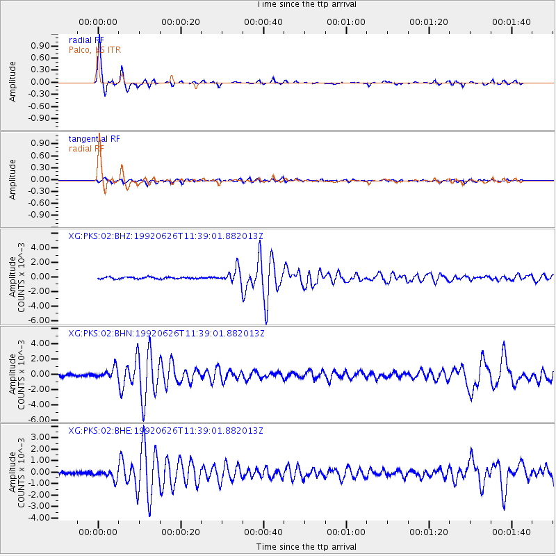
Signal To Noise
| Channel | StoN | STA | LTA |
| XG:PKS:02:BHN:19920626T11:39:01.882013Z | 4.930408 | 6.791048E-4 | 1.3773805E-4 |
| XG:PKS:02:BHE:19920626T11:39:01.882013Z | 3.6845417 | 4.039973E-4 | 1.0964656E-4 |
| XG:PKS:02:BHZ:19920626T11:39:01.882013Z | 8.783946 | 0.0010119627 | 1.15205934E-4 |
| Arrivals |
| Ps | 5.8 SECOND |
| PpPs | 17 SECOND |
| PsPs/PpSs | 22 SECOND |


