You are here: Home > Network List > XG92 - Rocky Mountain Front Stations List
> Station PKS Palco, KS > Earthquake Result Viewer
PKS Palco, KS - Earthquake Result Viewer
| Earthquake location: |
Andreanof Islands, Aleutian Is. |
| Earthquake latitude/longitude: |
51.5/-173.4 |
| Earthquake time(UTC): |
1992/06/24 (176) 12:11:26 GMT |
| Earthquake Depth: |
33 km |
| Earthquake Magnitude: |
5.7 MB, 5.4 MS, 5.7 ML |
| Earthquake Catalog/Contributor: |
WHDF/NEIC |
|
| Network: |
XG Rocky Mountain Front |
| Station: |
PKS Palco, KS |
| Lat/Lon: |
39.26 N/99.54 W |
| Elevation: |
673 m |
|
| Distance: |
51.2 deg |
| Az: |
73.199 deg |
| Baz: |
309.571 deg |
| Ray Param: |
0.06752927 |
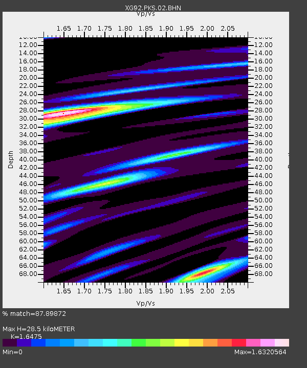
| Estimated Moho Depth: |
28.5 km |
| Estimated Crust Vp/Vs: |
1.65 |
| Assumed Crust Vp: |
6.483 km/s |
| Estimated Crust Vs: |
3.935 km/s |
| Estimated Crust Poisson's Ratio: |
0.21 |
|
| Radial Match: |
87.89872 % |
| Radial Bump: |
374 |
| Transverse Match: |
71.12868 % |
| Transverse Bump: |
400 |
| SOD ConfigId: |
3286 |
| Insert Time: |
2010-02-25 20:11:11.917 +0000 |
| GWidth: |
2.5 |
| Max Bumps: |
400 |
| Tol: |
0.001 |
|
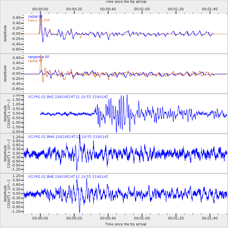
Signal To Noise
| Channel | StoN | STA | LTA |
| XG:PKS:02:BHN:19920624T12:19:55.339014Z | 1.0237759 | 1.634372E-4 | 1.5964158E-4 |
| XG:PKS:02:BHE:19920624T12:19:55.339014Z | 1.4604656 | 1.6146991E-4 | 1.1056058E-4 |
| XG:PKS:02:BHZ:19920624T12:19:55.339014Z | 4.7808776 | 3.9835548E-4 | 8.3322666E-5 |
| Arrivals |
| Ps | 3.0 SECOND |
| PpPs | 11 SECOND |
| PsPs/PpSs | 14 SECOND |


