You are here: Home > Network List > XG92 - Rocky Mountain Front Stations List
> Station POS Poncha Springs, CO > Earthquake Result Viewer
POS Poncha Springs, CO - Earthquake Result Viewer

| Earthquake location: |
Northern Peru |
| Earthquake latitude/longitude: |
-3.9/-76.6 |
| Earthquake time(UTC): |
1992/07/13 (195) 18:11:34 GMT |
| Earthquake Depth: |
100 km |
| Earthquake Magnitude: |
6.2 MB |
| Earthquake Catalog/Contributor: |
WHDF/NEIC |
|
| Network: |
XG Rocky Mountain Front |
| Station: |
POS Poncha Springs, CO |
| Lat/Lon: |
38.56 N/106.12 W |
| Elevation: |
2525 m |
|
| Distance: |
50.3 deg |
| Az: |
329.895 deg |
| Baz: |
140.335 deg |
| Ray Param: |
0.06780923 |
| Estimated Moho Depth: |
10.0 km |
| Estimated Crust Vp/Vs: |
1.60 |
| Assumed Crust Vp: |
6.306 km/s |
| Estimated Crust Vs: |
3.941 km/s |
| Estimated Crust Poisson's Ratio: |
0.18 |
|
| Radial Match: |
85.0535 % |
| Radial Bump: |
400 |
| Transverse Match: |
76.10029 % |
| Transverse Bump: |
400 |
| SOD ConfigId: |
3286 |
| Insert Time: |
2010-02-25 20:11:16.565 +0000 |
| GWidth: |
2.5 |
| Max Bumps: |
400 |
| Tol: |
0.001 |
|
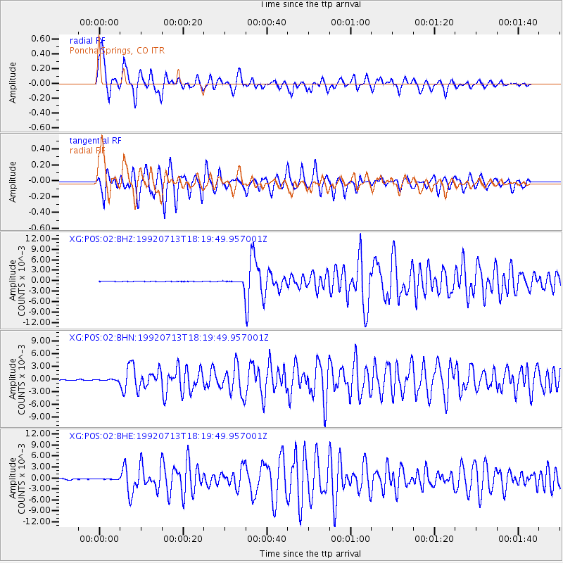
Signal To Noise
| Channel | StoN | STA | LTA |
| XG:POS:02:BHN:19920713T18:19:49.957001Z | 1.6696285 | 1.9627674E-4 | 1.1755713E-4 |
| XG:POS:02:BHE:19920713T18:19:49.957001Z | 0.62917376 | 7.69735E-5 | 1.223406E-4 |
| XG:POS:02:BHZ:19920713T18:19:49.957001Z | 12.200627 | 9.2602975E-4 | 7.590017E-5 |
| Arrivals |
| Ps | 1.0 SECOND |
| PpPs | 3.9 SECOND |
| PsPs/PpSs | 4.9 SECOND |


