
Station XG POS - Poncha Springs, CO
Network: XG92 - Rocky Mountain Front
Nearby stations (2 deg radius)
| Station | Name | (Lat, Lon) | Start / End | Elevation |
| POS | Poncha Springs, CO | (38.56, -106.12) | 1992-05-23 / 2499-01-01 | 2.5 km |
| Crust2 Type: | P4,orogen/50km, Urals, Tethian Orogen, Rockies 1 km seds. |
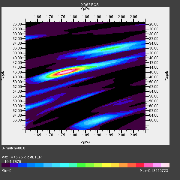
| Thickness Estimate: | 46 km |
| Thickness StdDev: | 4.2 km |
| Vp/Vs Estimate: | 1.77 |
| Vp/Vs StdDev: | 0.10 |
| Vs Estimate: | 3.568 km/s |
| Poisson's Ratio: | 0.26 |
| Peak Value: | 0.19 |
| Assumed Vp: | 6.306 km/s |
| Ps Weight: | 0.33333334 |
| PpPs Weight: | 0.33333334 |
| PsPs Weight: | 0.33333328 |
| Residual Complexity: | 0.563 |
| Nearby stations H: | +- |
| (2.0 deg) Vp/Vs: | +- |
1 with match > 90% ( 50.0 %) and 2 with match > 80% ( 100.0 %) out of 2.
Download stack as xyz text file.
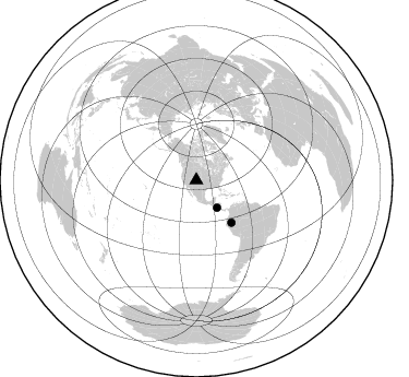
Azimuth Distribution of Events:
Prior Results for this Station
| Study | Thickness | Vp/Vs | Vp | Vs | Poissons Ratio | Extra |
| EARS | 46 km | 1.77 | 6.306 km/s | 3.568 km/s | 0.26 | |
| Crust2.0 | 50 km | 1.76 | 6.306 km/s | 3.584 km/s | 0.26 | P4,orogen/50km, Urals, Tethian Orogen, Rockies 1 km seds. |
| Global Maxima | 46 km | 1.77 | 6.306 km/s | 3.568 km/s | 0.26 | amp=0.18959723 |
| Local Maxima 1 | 36 km | 1.95 | 6.306 km/s | 3.238 km/s | 0.32 | amp=0.087616965 |
| Local Maxima 2 | 66 km | 1.90 | 6.306 km/s | 3.323 km/s | 0.31 | amp=0.07184246 |
| Local Maxima 3 | 42 km | 1.93 | 6.306 km/s | 3.259 km/s | 0.32 | amp=0.053649515 |
| Local Maxima 4 | 61 km | 1.60 | 6.306 km/s | 3.941 km/s | 0.18 | amp=0.050884444 |
| Predicted Arrivals for vertical incidence (zero ray parameter) | |
| Ps | 5.57 SECOND |
| PpPs | 20.08 SECOND |
| PsPs/PpSs | 25.65 SECOND |
Events Processed for this Station
Download zip of receiver functions as SAC
Plot maxima for each earthquake.
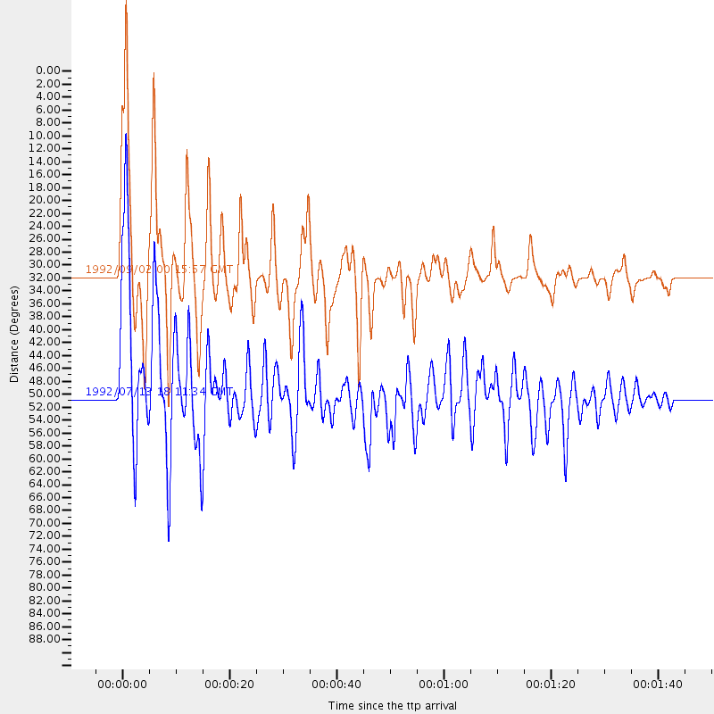
Events Used in the Stack
(2 events)| Radial Match | Distance | Baz | FERegion | Time | Lat/Lon | Depth | Magnitude |
| 92.811676 | 31.5 deg | 143.024 deg | Near Coast Of Nicaragua | 1992/09/02 00:15:57 GMT | (11.8, -87.4) | 10 km | 5.3 MB, 7.2 MS |
| 85.0535 | 50.3 deg | 140.335 deg | Northern Peru | 1992/07/13 18:11:34 GMT | (-3.9, -76.6) | 100 km | 6.2 MB |
Losers
(0 events)| Radial Match | Distance | Baz | FERegion | Time | Lat/Lon | Depth | Magnitude | Reason |
