You are here: Home > Network List > IC - New China Digital Seismograph Network Stations List
> Station HIA Hailar, Neimenggu Autonomous Region, China > Earthquake Result Viewer
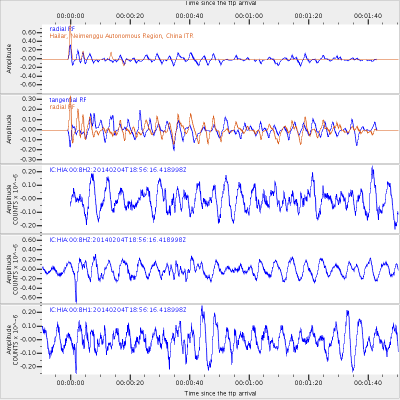
HIA Hailar, Neimenggu Autonomous Region, China - Earthquake Result Viewer
*The percent match for this event was below the threshold and hence no stack was calculated.
| Earthquake location: |
Mariana Islands |
| Earthquake latitude/longitude: |
13.4/144.2 |
| Earthquake time(UTC): |
2014/02/04 (035) 18:49:16 GMT |
| Earthquake Depth: |
135 km |
| Earthquake Magnitude: |
5.2 MW |
| Earthquake Catalog/Contributor: |
ISC/ISC |
|
| Network: |
IC New China Digital Seismograph Network |
| Station: |
HIA Hailar, Neimenggu Autonomous Region, China |
| Lat/Lon: |
49.27 N/119.74 E |
| Elevation: |
620 m |
|
| Distance: |
41.1 deg |
| Az: |
335.618 deg |
| Baz: |
142.167 deg |
| Ray Param: |
$rayparam |
*The percent match for this event was below the threshold and hence was not used in the summary stack. |
|
| Radial Match: |
54.53535 % |
| Radial Bump: |
400 |
| Transverse Match: |
52.377785 % |
| Transverse Bump: |
400 |
| SOD ConfigId: |
3390531 |
| Insert Time: |
2019-04-10 05:43:30.519 +0000 |
| GWidth: |
2.5 |
| Max Bumps: |
400 |
| Tol: |
0.001 |
|
Signal To Noise
| Channel | StoN | STA | LTA |
| IC:HIA:00:BHZ:20140204T18:56:16.418998Z | 3.8558261 | 2.1193517E-7 | 5.496492E-8 |
| IC:HIA:00:BH1:20140204T18:56:16.418998Z | 1.4413158 | 8.173771E-8 | 5.671048E-8 |
| IC:HIA:00:BH2:20140204T18:56:16.418998Z | 1.115916 | 8.398299E-8 | 7.525924E-8 |
| Arrivals |
| Ps | |
| PpPs | |
| PsPs/PpSs | |


