You are here: Home > Network List > XG92 - Rocky Mountain Front Stations List
> Station SPR Springfield, CO > Earthquake Result Viewer
SPR Springfield, CO - Earthquake Result Viewer
| Earthquake location: |
Southeast Of Honshu, Japan |
| Earthquake latitude/longitude: |
33.2/138.0 |
| Earthquake time(UTC): |
1992/08/29 (242) 19:19:07 GMT |
| Earthquake Depth: |
309 km |
| Earthquake Magnitude: |
6.0 MB |
| Earthquake Catalog/Contributor: |
WHDF/NEIC |
|
| Network: |
XG Rocky Mountain Front |
| Station: |
SPR Springfield, CO |
| Lat/Lon: |
37.46 N/102.64 W |
| Elevation: |
1327 m |
|
| Distance: |
89.9 deg |
| Az: |
43.922 deg |
| Baz: |
313.009 deg |
| Ray Param: |
0.041642662 |
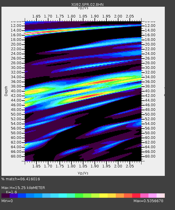
| Estimated Moho Depth: |
15.25 km |
| Estimated Crust Vp/Vs: |
1.60 |
| Assumed Crust Vp: |
6.306 km/s |
| Estimated Crust Vs: |
3.941 km/s |
| Estimated Crust Poisson's Ratio: |
0.18 |
|
| Radial Match: |
86.416016 % |
| Radial Bump: |
400 |
| Transverse Match: |
66.36259 % |
| Transverse Bump: |
400 |
| SOD ConfigId: |
3286 |
| Insert Time: |
2010-02-25 20:11:38.836 +0000 |
| GWidth: |
2.5 |
| Max Bumps: |
400 |
| Tol: |
0.001 |
|
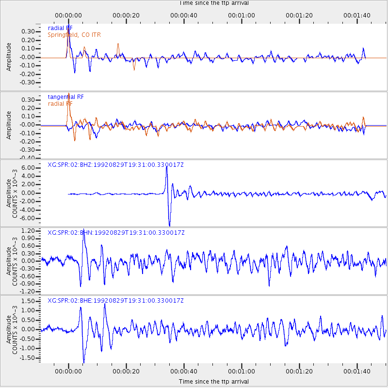
Signal To Noise
| Channel | StoN | STA | LTA |
| XG:SPR:02:BHN:19920829T19:31:00.330017Z | 2.1680005 | 3.0730155E-4 | 1.4174423E-4 |
| XG:SPR:02:BHE:19920829T19:31:00.330017Z | 4.144095 | 4.0671497E-4 | 9.814326E-5 |
| XG:SPR:02:BHZ:19920829T19:31:00.330017Z | 21.73098 | 0.002183243 | 1.0046685E-4 |
| Arrivals |
| Ps | 1.5 SECOND |
| PpPs | 6.2 SECOND |
| PsPs/PpSs | 7.6 SECOND |


