
Station XG SPR - Springfield, CO
Network: XG92 - Rocky Mountain Front
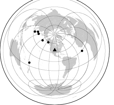
Nearby stations (2 deg radius)
| Station | Name | (Lat, Lon) | Start / End | Elevation |
| SPR | Springfield, CO | (37.46, -102.64) | 1992-06-20 / 2499-01-01 | 1.3 km |
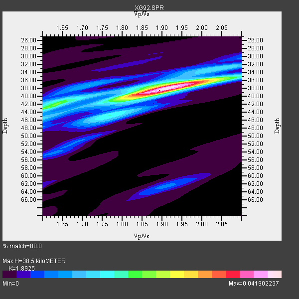
| Crust2 Type: | P4,orogen/50km, Urals, Tethian Orogen, Rockies 1 km seds. |
| Thickness Estimate: | 38 km |
| Thickness StdDev: | 0.9 km |
| Vp/Vs Estimate: | 1.89 |
| Vp/Vs StdDev: | 0.04 |
| Vs Estimate: | 3.332 km/s |
| Poisson's Ratio: | 0.31 |
| Peak Value: | 0.04 |
| Assumed Vp: | 6.306 km/s |
| Ps Weight: | 0.33333334 |
| PpPs Weight: | 0.33333334 |
| PsPs Weight: | 0.33333328 |
| Residual Complexity: | 0.473 |
| Nearby stations H: | +- |
| (2.0 deg) Vp/Vs: | +- |
4 with match > 90% ( 57.142857 %) and 7 with match > 80% ( 100.0 %) out of 7.
Download stack as xyz text file.
Azimuth Distribution of Events:
Prior Results for this Station
| Study | Thickness | Vp/Vs | Vp | Vs | Poissons Ratio | Extra |
| EARS | 38 km | 1.89 | 6.306 km/s | 3.332 km/s | 0.31 | |
| Crust2.0 | 50 km | 1.76 | 6.306 km/s | 3.584 km/s | 0.26 | P4,orogen/50km, Urals, Tethian Orogen, Rockies 1 km seds. |
| Global Maxima | 38 km | 1.89 | 6.306 km/s | 3.332 km/s | 0.31 | amp=0.041902237 |
| Local Maxima 1 | 36 km | 1.97 | 6.306 km/s | 3.209 km/s | 0.33 | amp=0.019321151 |
| Local Maxima 2 | 43 km | 1.60 | 6.306 km/s | 3.935 km/s | 0.18 | amp=0.013560211 |
| Local Maxima 3 | 41 km | 1.81 | 6.306 km/s | 3.479 km/s | 0.28 | amp=0.010749926 |
| Local Maxima 4 | 37 km | 1.72 | 6.306 km/s | 3.672 km/s | 0.24 | amp=0.009417016 |
| Predicted Arrivals for vertical incidence (zero ray parameter) | |
| Ps | 5.45 SECOND |
| PpPs | 17.66 SECOND |
| PsPs/PpSs | 23.11 SECOND |
Events Processed for this Station
Download zip of receiver functions as SAC
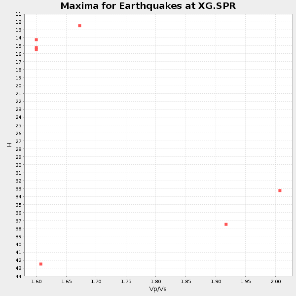
Plot maxima for each earthquake.
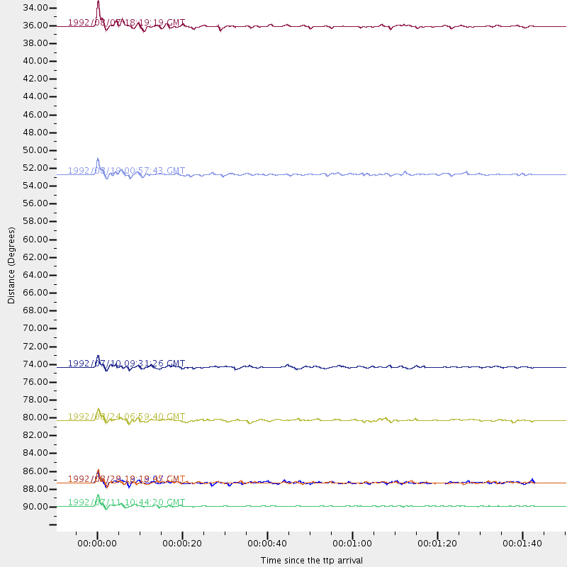
Events Used in the Stack
(7 events)| Radial Match | Distance | Baz | FERegion | Time | Lat/Lon | Depth | Magnitude |
| 94.23305 | 92.8 deg | 244.056 deg | South Of Fiji Islands | 1992/07/11 10:44:20 GMT | (-22.3, -178.5) | 381 km | 6.2 MB |
| 93.65547 | 89.9 deg | 91.343 deg | North Of Ascension Island | 1992/08/28 18:18:45 GMT | (-1.0, -13.6) | 10 km | 6.4 MB, 7.0 MS |
| 92.48662 | 51.6 deg | 309.074 deg | Andreanof Islands, Aleutian Is. | 1992/08/19 00:57:43 GMT | (50.5, -174.8) | 33 km | 6.1 MB, 5.7 MS, 5.6 ML |
| 91.49392 | 75.5 deg | 315.453 deg | Kuril Islands | 1992/07/10 09:31:26 GMT | (44.7, 149.5) | 11 km | 6.1 MB, 6.5 MS |
| 89.85408 | 33.2 deg | 320.437 deg | Gulf Of Alaska | 1992/08/07 18:19:19 GMT | (57.6, -143.0) | 10 km | 6.3 MB, 6.5 MS, 6.5 ML |
| 86.416016 | 89.9 deg | 313.009 deg | Southeast Of Honshu, Japan | 1992/08/29 19:19:07 GMT | (33.2, 138.0) | 309 km | 6.0 MB |
| 83.661995 | 82.1 deg | 317.683 deg | Hokkaido, Japan Region | 1992/08/24 06:59:40 GMT | (41.9, 140.7) | 127 km | 6.2 MB |
Losers
(0 events)| Radial Match | Distance | Baz | FERegion | Time | Lat/Lon | Depth | Magnitude | Reason |
