You are here: Home > Network List > XG92 - Rocky Mountain Front Stations List
> Station SPR Springfield, CO > Earthquake Result Viewer
SPR Springfield, CO - Earthquake Result Viewer
| Earthquake location: |
North Of Ascension Island |
| Earthquake latitude/longitude: |
-1.0/-13.6 |
| Earthquake time(UTC): |
1992/08/28 (241) 18:18:45 GMT |
| Earthquake Depth: |
10 km |
| Earthquake Magnitude: |
6.4 MB, 7.0 MS |
| Earthquake Catalog/Contributor: |
WHDF/NEIC |
|
| Network: |
XG Rocky Mountain Front |
| Station: |
SPR Springfield, CO |
| Lat/Lon: |
37.46 N/102.64 W |
| Elevation: |
1327 m |
|
| Distance: |
89.9 deg |
| Az: |
307.283 deg |
| Baz: |
91.343 deg |
| Ray Param: |
0.041713916 |
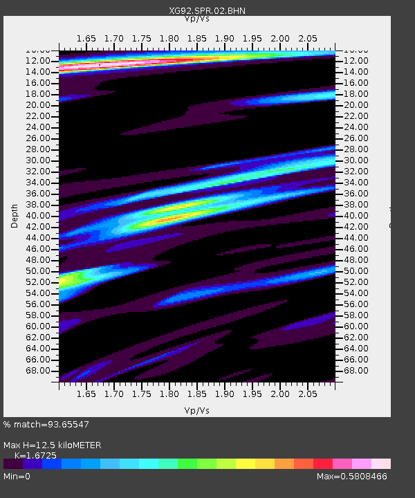
| Estimated Moho Depth: |
12.5 km |
| Estimated Crust Vp/Vs: |
1.67 |
| Assumed Crust Vp: |
6.306 km/s |
| Estimated Crust Vs: |
3.77 km/s |
| Estimated Crust Poisson's Ratio: |
0.22 |
|
| Radial Match: |
93.65547 % |
| Radial Bump: |
246 |
| Transverse Match: |
79.1181 % |
| Transverse Bump: |
400 |
| SOD ConfigId: |
3286 |
| Insert Time: |
2010-02-25 20:11:41.620 +0000 |
| GWidth: |
2.5 |
| Max Bumps: |
400 |
| Tol: |
0.001 |
|
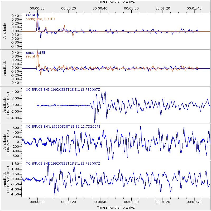
Signal To Noise
| Channel | StoN | STA | LTA |
| XG:SPR:02:BHN:19920828T18:31:12.732007Z | 1.0923605 | 1.053319E-4 | 9.642595E-5 |
| XG:SPR:02:BHE:19920828T18:31:12.732007Z | 1.1265392 | 1.15024166E-4 | 1.0210401E-4 |
| XG:SPR:02:BHZ:19920828T18:31:12.732007Z | 2.4879172 | 2.229786E-4 | 8.9624606E-5 |
| Arrivals |
| Ps | 1.4 SECOND |
| PpPs | 5.2 SECOND |
| PsPs/PpSs | 6.5 SECOND |


