You are here: Home > Network List > XG92 - Rocky Mountain Front Stations List
> Station SPR Springfield, CO > Earthquake Result Viewer
SPR Springfield, CO - Earthquake Result Viewer
| Earthquake location: |
Hokkaido, Japan Region |
| Earthquake latitude/longitude: |
41.9/140.7 |
| Earthquake time(UTC): |
1992/08/24 (237) 06:59:40 GMT |
| Earthquake Depth: |
127 km |
| Earthquake Magnitude: |
6.2 MB |
| Earthquake Catalog/Contributor: |
WHDF/NEIC |
|
| Network: |
XG Rocky Mountain Front |
| Station: |
SPR Springfield, CO |
| Lat/Lon: |
37.46 N/102.64 W |
| Elevation: |
1327 m |
|
| Distance: |
82.1 deg |
| Az: |
45.895 deg |
| Baz: |
317.683 deg |
| Ray Param: |
0.046819236 |
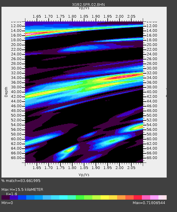
| Estimated Moho Depth: |
15.5 km |
| Estimated Crust Vp/Vs: |
1.60 |
| Assumed Crust Vp: |
6.306 km/s |
| Estimated Crust Vs: |
3.941 km/s |
| Estimated Crust Poisson's Ratio: |
0.18 |
|
| Radial Match: |
83.661995 % |
| Radial Bump: |
400 |
| Transverse Match: |
73.30654 % |
| Transverse Bump: |
400 |
| SOD ConfigId: |
3286 |
| Insert Time: |
2010-02-25 20:11:43.260 +0000 |
| GWidth: |
2.5 |
| Max Bumps: |
400 |
| Tol: |
0.001 |
|
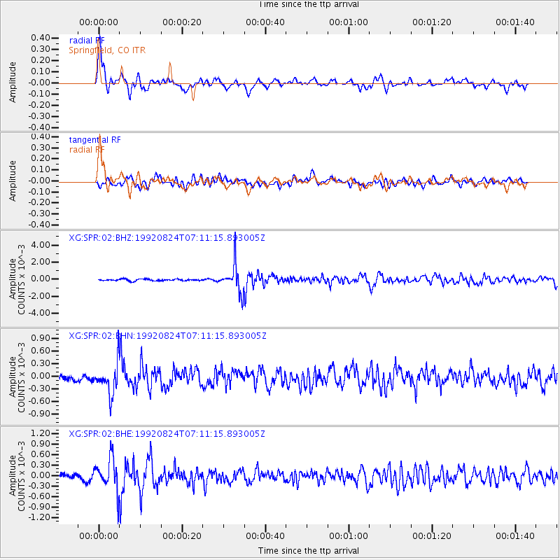
Signal To Noise
| Channel | StoN | STA | LTA |
| XG:SPR:02:BHN:19920824T07:11:15.893005Z | 4.072706 | 3.8043558E-4 | 9.3411E-5 |
| XG:SPR:02:BHE:19920824T07:11:15.893005Z | 5.800057 | 4.7081942E-4 | 8.117496E-5 |
| XG:SPR:02:BHZ:19920824T07:11:15.893005Z | 17.378424 | 0.0016986423 | 9.774432E-5 |
| Arrivals |
| Ps | 1.5 SECOND |
| PpPs | 6.2 SECOND |
| PsPs/PpSs | 7.7 SECOND |


