You are here: Home > Network List > XG92 - Rocky Mountain Front Stations List
> Station SPR Springfield, CO > Earthquake Result Viewer
SPR Springfield, CO - Earthquake Result Viewer
| Earthquake location: |
South Of Fiji Islands |
| Earthquake latitude/longitude: |
-22.3/-178.5 |
| Earthquake time(UTC): |
1992/07/11 (193) 10:44:20 GMT |
| Earthquake Depth: |
381 km |
| Earthquake Magnitude: |
6.2 MB |
| Earthquake Catalog/Contributor: |
WHDF/NEIC |
|
| Network: |
XG Rocky Mountain Front |
| Station: |
SPR Springfield, CO |
| Lat/Lon: |
37.46 N/102.64 W |
| Elevation: |
1327 m |
|
| Distance: |
92.8 deg |
| Az: |
50.586 deg |
| Baz: |
244.056 deg |
| Ray Param: |
0.04113209 |
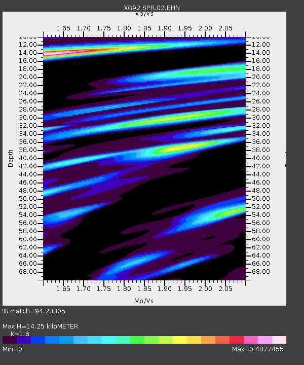
| Estimated Moho Depth: |
14.25 km |
| Estimated Crust Vp/Vs: |
1.60 |
| Assumed Crust Vp: |
6.306 km/s |
| Estimated Crust Vs: |
3.941 km/s |
| Estimated Crust Poisson's Ratio: |
0.18 |
|
| Radial Match: |
94.23305 % |
| Radial Bump: |
337 |
| Transverse Match: |
79.510895 % |
| Transverse Bump: |
400 |
| SOD ConfigId: |
3286 |
| Insert Time: |
2010-02-25 20:11:46.408 +0000 |
| GWidth: |
2.5 |
| Max Bumps: |
400 |
| Tol: |
0.001 |
|
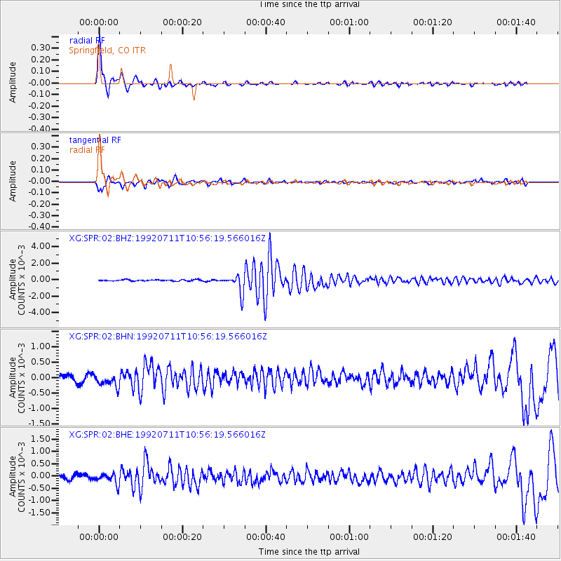
Signal To Noise
| Channel | StoN | STA | LTA |
| XG:SPR:02:BHN:19920711T10:56:19.566016Z | 1.9209459 | 2.1986695E-4 | 1.1445765E-4 |
| XG:SPR:02:BHE:19920711T10:56:19.566016Z | 2.568377 | 2.1274447E-4 | 8.283226E-5 |
| XG:SPR:02:BHZ:19920711T10:56:19.566016Z | 14.95622 | 0.0011500729 | 7.6895965E-5 |
| Arrivals |
| Ps | 1.4 SECOND |
| PpPs | 5.8 SECOND |
| PsPs/PpSs | 7.1 SECOND |


