You are here: Home > Network List > XG92 - Rocky Mountain Front Stations List
> Station SPR Springfield, CO > Earthquake Result Viewer
SPR Springfield, CO - Earthquake Result Viewer
| Earthquake location: |
Kuril Islands |
| Earthquake latitude/longitude: |
44.7/149.5 |
| Earthquake time(UTC): |
1992/07/10 (192) 09:31:26 GMT |
| Earthquake Depth: |
11 km |
| Earthquake Magnitude: |
6.1 MB, 6.5 MS |
| Earthquake Catalog/Contributor: |
WHDF/NEIC |
|
| Network: |
XG Rocky Mountain Front |
| Station: |
SPR Springfield, CO |
| Lat/Lon: |
37.46 N/102.64 W |
| Elevation: |
1327 m |
|
| Distance: |
75.5 deg |
| Az: |
51.47 deg |
| Baz: |
315.453 deg |
| Ray Param: |
0.051615946 |
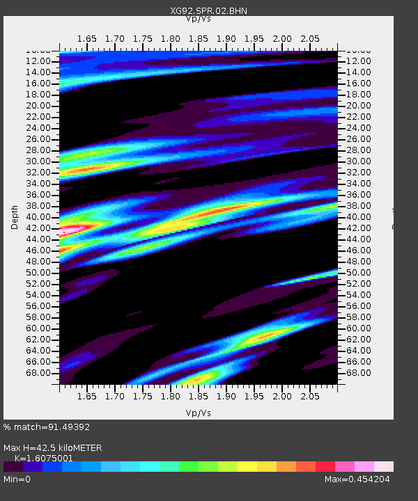
| Estimated Moho Depth: |
42.5 km |
| Estimated Crust Vp/Vs: |
1.61 |
| Assumed Crust Vp: |
6.306 km/s |
| Estimated Crust Vs: |
3.923 km/s |
| Estimated Crust Poisson's Ratio: |
0.18 |
|
| Radial Match: |
91.49392 % |
| Radial Bump: |
400 |
| Transverse Match: |
77.653145 % |
| Transverse Bump: |
400 |
| SOD ConfigId: |
3286 |
| Insert Time: |
2010-02-25 20:11:47.716 +0000 |
| GWidth: |
2.5 |
| Max Bumps: |
400 |
| Tol: |
0.001 |
|
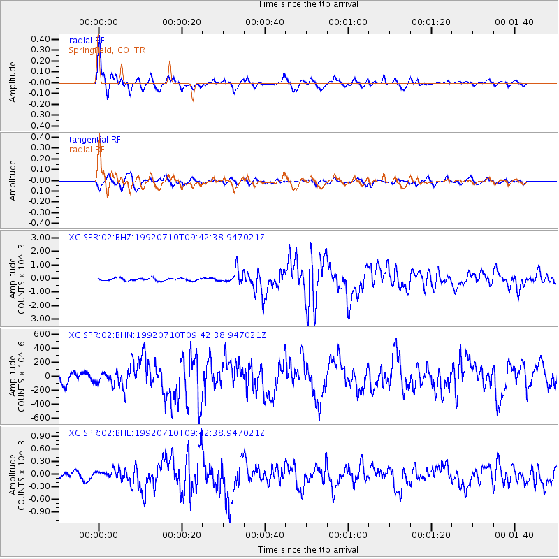
Signal To Noise
| Channel | StoN | STA | LTA |
| XG:SPR:02:BHN:19920710T09:42:38.947021Z | 1.0993477 | 7.6454715E-5 | 6.9545524E-5 |
| XG:SPR:02:BHE:19920710T09:42:38.947021Z | 1.194916 | 9.810855E-5 | 8.210497E-5 |
| XG:SPR:02:BHZ:19920710T09:42:38.947021Z | 5.1956854 | 4.985519E-4 | 9.595497E-5 |
| Arrivals |
| Ps | 4.2 SECOND |
| PpPs | 17 SECOND |
| PsPs/PpSs | 21 SECOND |


