You are here: Home > Network List > XG92 - Rocky Mountain Front Stations List
> Station SPR Springfield, CO > Earthquake Result Viewer
SPR Springfield, CO - Earthquake Result Viewer
| Earthquake location: |
Andreanof Islands, Aleutian Is. |
| Earthquake latitude/longitude: |
50.5/-174.8 |
| Earthquake time(UTC): |
1992/08/19 (232) 00:57:43 GMT |
| Earthquake Depth: |
33 km |
| Earthquake Magnitude: |
6.1 MB, 5.7 MS, 5.6 ML |
| Earthquake Catalog/Contributor: |
WHDF/NEIC |
|
| Network: |
XG Rocky Mountain Front |
| Station: |
SPR Springfield, CO |
| Lat/Lon: |
37.46 N/102.64 W |
| Elevation: |
1327 m |
|
| Distance: |
51.6 deg |
| Az: |
75.224 deg |
| Baz: |
309.074 deg |
| Ray Param: |
0.06725087 |
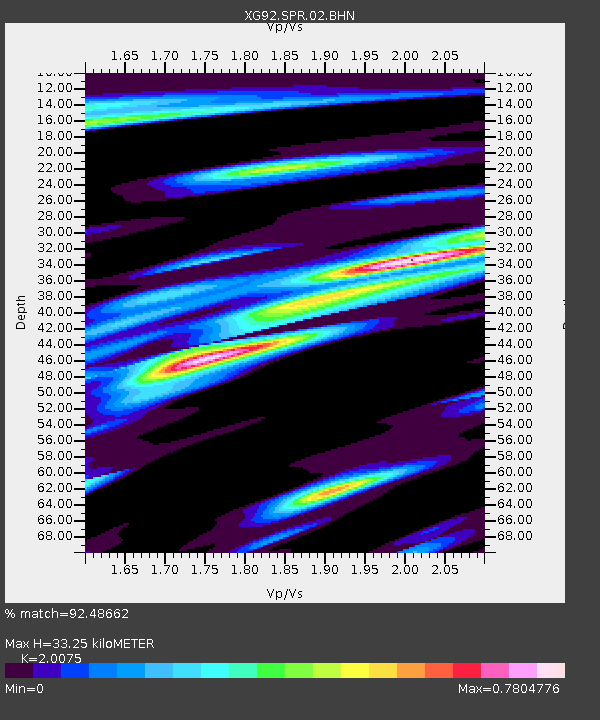
| Estimated Moho Depth: |
33.25 km |
| Estimated Crust Vp/Vs: |
2.01 |
| Assumed Crust Vp: |
6.306 km/s |
| Estimated Crust Vs: |
3.141 km/s |
| Estimated Crust Poisson's Ratio: |
0.33 |
|
| Radial Match: |
92.48662 % |
| Radial Bump: |
373 |
| Transverse Match: |
71.58331 % |
| Transverse Bump: |
400 |
| SOD ConfigId: |
3286 |
| Insert Time: |
2010-02-25 20:11:49.728 +0000 |
| GWidth: |
2.5 |
| Max Bumps: |
400 |
| Tol: |
0.001 |
|
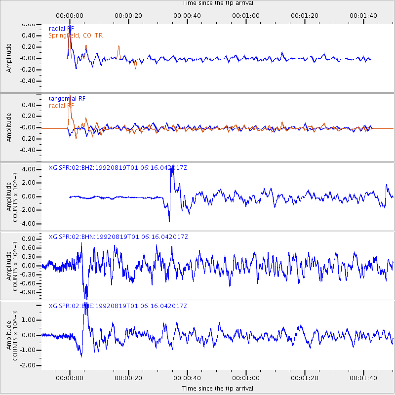
Signal To Noise
| Channel | StoN | STA | LTA |
| XG:SPR:02:BHN:19920819T01:06:16.042017Z | 3.2430084 | 2.995553E-4 | 9.236957E-5 |
| XG:SPR:02:BHE:19920819T01:06:16.042017Z | 7.7241154 | 5.980641E-4 | 7.7428165E-5 |
| XG:SPR:02:BHZ:19920819T01:06:16.042017Z | 17.167416 | 0.0016004827 | 9.322794E-5 |
| Arrivals |
| Ps | 5.6 SECOND |
| PpPs | 15 SECOND |
| PsPs/PpSs | 21 SECOND |


