You are here: Home > Network List > XG92 - Rocky Mountain Front Stations List
> Station YUM Yuma, CO > Earthquake Result Viewer
YUM Yuma, CO - Earthquake Result Viewer
| Earthquake location: |
Andreanof Islands, Aleutian Is. |
| Earthquake latitude/longitude: |
50.5/-174.8 |
| Earthquake time(UTC): |
1992/08/19 (232) 00:57:43 GMT |
| Earthquake Depth: |
33 km |
| Earthquake Magnitude: |
6.1 MB, 5.7 MS, 5.6 ML |
| Earthquake Catalog/Contributor: |
WHDF/NEIC |
|
| Network: |
XG Rocky Mountain Front |
| Station: |
YUM Yuma, CO |
| Lat/Lon: |
40.16 N/102.78 W |
| Elevation: |
1284 m |
|
| Distance: |
49.8 deg |
| Az: |
72.569 deg |
| Baz: |
307.305 deg |
| Ray Param: |
0.06838549 |
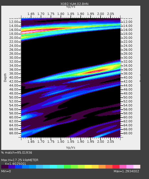
| Estimated Moho Depth: |
17.25 km |
| Estimated Crust Vp/Vs: |
1.60 |
| Assumed Crust Vp: |
6.483 km/s |
| Estimated Crust Vs: |
4.045 km/s |
| Estimated Crust Poisson's Ratio: |
0.18 |
|
| Radial Match: |
95.01936 % |
| Radial Bump: |
331 |
| Transverse Match: |
81.545555 % |
| Transverse Bump: |
400 |
| SOD ConfigId: |
3286 |
| Insert Time: |
2010-02-25 20:12:25.554 +0000 |
| GWidth: |
2.5 |
| Max Bumps: |
400 |
| Tol: |
0.001 |
|

Signal To Noise
| Channel | StoN | STA | LTA |
| XG:YUM:02:BHN:19920819T01:06:02.839014Z | 0.59392554 | 9.036881E-5 | 1.5215512E-4 |
| XG:YUM:02:BHE:19920819T01:06:02.839014Z | 1.0093783 | 1.04589184E-4 | 1.0361743E-4 |
| XG:YUM:02:BHZ:19920819T01:06:02.839014Z | 6.07168 | 6.264445E-4 | 1.0317482E-4 |
| Arrivals |
| Ps | 1.7 SECOND |
| PpPs | 6.5 SECOND |
| PsPs/PpSs | 8.2 SECOND |


