
Station XG YUM - Yuma, CO
Network: XG92 - Rocky Mountain Front
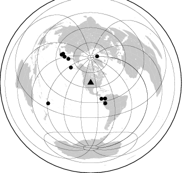
Nearby stations (2 deg radius)
| Station | Name | (Lat, Lon) | Start / End | Elevation |
| YUM | Yuma, CO | (40.16, -102.78) | 1992-05-23 / 2499-01-01 | 1.3 km |
| Crust2 Type: | D5,thick Platform 2 km seds. |
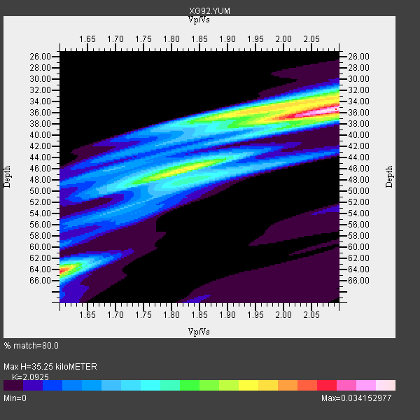
| Thickness Estimate: | 35 km |
| Thickness StdDev: | 11 km |
| Vp/Vs Estimate: | 2.09 |
| Vp/Vs StdDev: | 0.19 |
| Vs Estimate: | 3.098 km/s |
| Poisson's Ratio: | 0.35 |
| Peak Value: | 0.03 |
| Assumed Vp: | 6.483 km/s |
| Ps Weight: | 0.33333334 |
| PpPs Weight: | 0.33333334 |
| PsPs Weight: | 0.33333328 |
| Residual Complexity: | 0.735 |
| Nearby stations H: | +- |
| (2.0 deg) Vp/Vs: | +- |
9 with match > 90% ( 90.0 %) and 10 with match > 80% ( 100.0 %) out of 10.
Download stack as xyz text file.
Azimuth Distribution of Events:
Prior Results for this Station
| Study | Thickness | Vp/Vs | Vp | Vs | Poissons Ratio | Extra |
| EARS | 35 km | 2.09 | 6.483 km/s | 3.098 km/s | 0.35 | |
| Crust2.0 | 46 km | 1.78 | 6.483 km/s | 3.648 km/s | 0.27 | D5,thick Platform 2 km seds. |
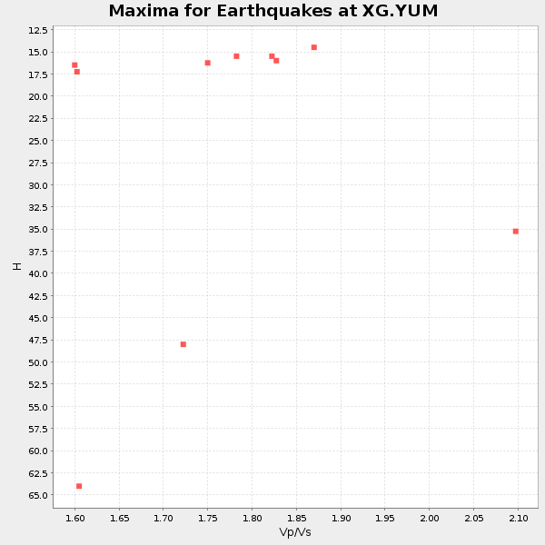
| Global Maxima | 35 km | 2.09 | 6.483 km/s | 3.098 km/s | 0.35 | amp=0.034152977 |
| Local Maxima 1 | 64 km | 1.60 | 6.483 km/s | 4.052 km/s | 0.18 | amp=0.022882015 |
| Local Maxima 2 | 35 km | 1.98 | 6.483 km/s | 3.27 km/s | 0.33 | amp=0.022632128 |
| Local Maxima 3 | 47 km | 1.79 | 6.483 km/s | 3.617 km/s | 0.27 | amp=0.01856267 |
| Local Maxima 4 | 48 km | 1.86 | 6.483 km/s | 3.49 km/s | 0.30 | amp=0.012368948 |
| Predicted Arrivals for vertical incidence (zero ray parameter) | |
| Ps | 5.94 SECOND |
| PpPs | 16.82 SECOND |
| PsPs/PpSs | 22.76 SECOND |
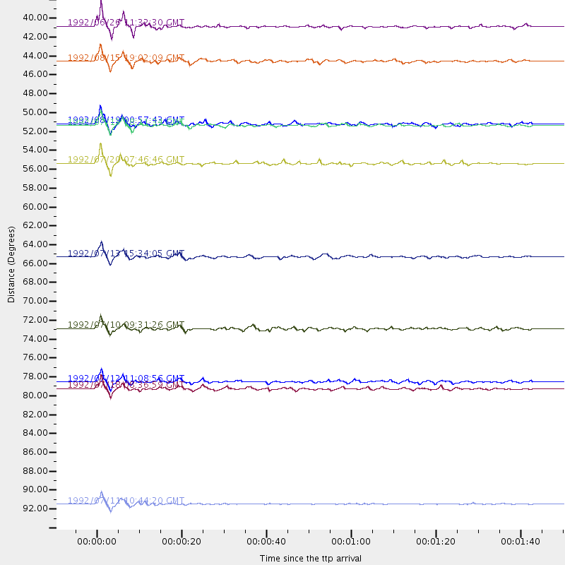
Events Processed for this Station
Download zip of receiver functions as SAC
Plot maxima for each earthquake.
Events Used in the Stack
(10 events)| Radial Match | Distance | Baz | FERegion | Time | Lat/Lon | Depth | Magnitude |
| 95.79734 | 54.4 deg | 13.624 deg | Svalbard Region | 1992/07/20 07:46:46 GMT | (78.5, 5.1) | 10 km | 5.8 MB, 6.3 MS |
| 95.44204 | 93.9 deg | 244.112 deg | South Of Fiji Islands | 1992/07/11 10:44:20 GMT | (-22.3, -178.5) | 381 km | 6.2 MB |
| 95.10041 | 65.2 deg | 316.851 deg | Near East Coast Of Kamchatka | 1992/07/13 15:34:05 GMT | (51.2, 157.7) | 53 km | 5.7 MB |
| 95.08938 | 50.0 deg | 144.974 deg | Northern Peru | 1992/07/13 18:11:34 GMT | (-3.9, -76.6) | 100 km | 6.2 MB |
| 95.01936 | 49.8 deg | 307.305 deg | Andreanof Islands, Aleutian Is. | 1992/08/19 00:57:43 GMT | (50.5, -174.8) | 33 km | 6.1 MB, 5.7 MS, 5.6 ML |
| 93.15298 | 38.5 deg | 146.168 deg | South Of Panama | 1992/06/26 11:32:30 GMT | (6.1, -82.4) | 33 km | 5.8 MB, 5.4 MS |
| 91.2092 | 80.5 deg | 314.027 deg | Off East Coast Of Honshu, Japan | 1992/07/18 08:36:59 GMT | (39.4, 143.4) | 33 km | 6.1 MB, 6.9 MS |
| 90.96868 | 79.7 deg | 316.247 deg | Hokkaido, Japan Region | 1992/07/12 11:08:56 GMT | (41.4, 142.1) | 70 km | 5.9 MB |
| 90.091995 | 42.6 deg | 137.967 deg | Colombia | 1992/08/15 19:02:09 GMT | (5.1, -75.7) | 127 km | 5.7 MB |
| 86.0807 | 73.5 deg | 314.86 deg | Kuril Islands | 1992/07/10 09:31:26 GMT | (44.7, 149.5) | 11 km | 6.1 MB, 6.5 MS |
Losers
(0 events)| Radial Match | Distance | Baz | FERegion | Time | Lat/Lon | Depth | Magnitude | Reason |
