You are here: Home > Network List > XK12 - Seismic Arrays for African Rift Initation Stations List
> Station Z06GL Zungulila Bush Camp, South Luangwa National Park, > Earthquake Result Viewer
Z06GL Zungulila Bush Camp, South Luangwa National Park, - Earthquake Result Viewer
| Earthquake location: |
Xizang |
| Earthquake latitude/longitude: |
35.9/82.6 |
| Earthquake time(UTC): |
2014/02/12 (043) 09:19:49 GMT |
| Earthquake Depth: |
10 km |
| Earthquake Magnitude: |
6.9 MWW, 6.9 MWB, 6.9 MWC |
| Earthquake Catalog/Contributor: |
NEIC PDE/NEIC COMCAT |
|
| Network: |
XK Seismic Arrays for African Rift Initation |
| Station: |
Z06GL Zungulila Bush Camp, South Luangwa National Park, |
| Lat/Lon: |
13.35 S/31.51 E |
| Elevation: |
520 m |
|
| Distance: |
68.7 deg |
| Az: |
234.337 deg |
| Baz: |
42.662 deg |
| Ray Param: |
0.05610456 |
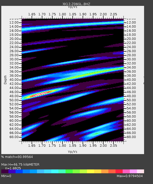
| Estimated Moho Depth: |
46.75 km |
| Estimated Crust Vp/Vs: |
1.69 |
| Assumed Crust Vp: |
6.367 km/s |
| Estimated Crust Vs: |
3.762 km/s |
| Estimated Crust Poisson's Ratio: |
0.23 |
|
| Radial Match: |
80.99564 % |
| Radial Bump: |
386 |
| Transverse Match: |
74.06726 % |
| Transverse Bump: |
400 |
| SOD ConfigId: |
3390531 |
| Insert Time: |
2019-04-10 08:01:34.029 +0000 |
| GWidth: |
2.5 |
| Max Bumps: |
400 |
| Tol: |
0.001 |
|

Signal To Noise
| Channel | StoN | STA | LTA |
| XK:Z06GL: :BHZ:20140212T09:30:21.940005Z | 8.260039 | 1.5645863E-6 | 1.8941633E-7 |
| XK:Z06GL: :BHN:20140212T09:30:21.940005Z | 2.3990827 | 7.4753433E-7 | 3.1159175E-7 |
| XK:Z06GL: :BHE:20140212T09:30:21.940005Z | 1.7717545 | 6.0773567E-7 | 3.4301345E-7 |
| Arrivals |
| Ps | 5.3 SECOND |
| PpPs | 19 SECOND |
| PsPs/PpSs | 24 SECOND |


