
Station XK Z06GL - Zungulila Bush Camp, South Luangwa National Park,
Network: XK12 - Seismic Arrays for African Rift Initation
Nearby stations (2 deg radius)
| Station | Name | (Lat, Lon) | Start / End | Elevation |
| Z06GL | Zungulila Bush Camp, South Luangwa National Park, | (-13.35, 31.51) | 2013-06-29 / 2014-08-30 | 520 m |
| Crust2 Type: | G0,Archean 1 km seds., Hudson Platform |
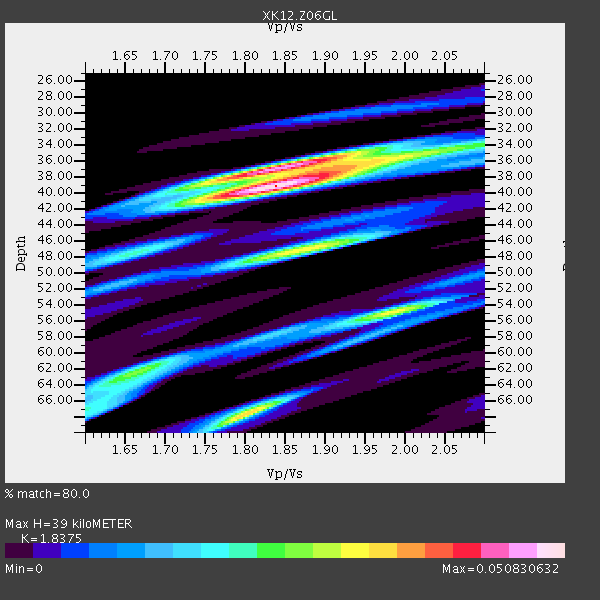
| Thickness Estimate: | 39 km |
| Thickness StdDev: | 11 km |
| Vp/Vs Estimate: | 1.84 |
| Vp/Vs StdDev: | 0.07 |
| Vs Estimate: | 3.465 km/s |
| Poisson's Ratio: | 0.29 |
| Peak Value: | 0.05 |
| Assumed Vp: | 6.367 km/s |
| Ps Weight: | 0.33333334 |
| PpPs Weight: | 0.33333334 |
| PsPs Weight: | 0.33333328 |
| Residual Complexity: | 0.727 |
| Nearby stations H: | +- |
| (2.0 deg) Vp/Vs: | +- |
0 with match > 90% ( 0.0 %) and 2 with match > 80% ( 10.526316 %) out of 19.
Download stack as xyz text file.
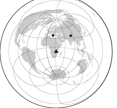
Azimuth Distribution of Events:
Prior Results for this Station
| Study | Thickness | Vp/Vs | Vp | Vs | Poissons Ratio | Extra |
| EARS | 39 km | 1.84 | 6.367 km/s | 3.465 km/s | 0.29 | |
| Crust2.0 | 39 km | 1.77 | 6.367 km/s | 3.605 km/s | 0.26 | G0,Archean 1 km seds., Hudson Platform |
| Global Maxima | 39 km | 1.84 | 6.367 km/s | 3.465 km/s | 0.29 | amp=0.050830632 |
| Local Maxima 1 | 37 km | 1.83 | 6.367 km/s | 3.484 km/s | 0.29 | amp=0.039178573 |
| Local Maxima 2 | 68 km | 1.80 | 6.367 km/s | 3.532 km/s | 0.28 | amp=0.035160094 |
| Local Maxima 3 | 47 km | 1.87 | 6.367 km/s | 3.405 km/s | 0.30 | amp=0.032339554 |
| Local Maxima 4 | 55 km | 1.99 | 6.367 km/s | 3.207 km/s | 0.33 | amp=0.025744198 |
| Predicted Arrivals for vertical incidence (zero ray parameter) | |
| Ps | 5.13 SECOND |
| PpPs | 17.38 SECOND |
| PsPs/PpSs | 22.51 SECOND |
Events Processed for this Station
Download zip of receiver functions as SAC
Plot maxima for each earthquake.
Events Used in the Stack
(2 events)| Radial Match | Distance | Baz | FERegion | Time | Lat/Lon | Depth | Magnitude |
| 81.95387 | 52.4 deg | 348.946 deg | Greece | 2014/02/03 03:08:46 GMT | (38.3, 20.4) | 5.0 km | 6.0 MWW, 6.0 MWB, 6.1 MWC |
| 80.99564 | 68.7 deg | 42.662 deg | Xizang | 2014/02/12 09:19:49 GMT | (35.9, 82.6) | 10 km | 6.9 MWW, 6.9 MWB, 6.9 MWC |
Losers
(17 events)| Radial Match | Distance | Baz | FERegion | Time | Lat/Lon | Depth | Magnitude | Reason |
| 73.03916 | 52.3 deg | 348.885 deg | Greece | 2014/02/03 03:16:14 GMT | (38.2, 20.3) | 13 km | 4.1 mb | |
| 68.33307 | 62.1 deg | 212.177 deg | South Sandwich Islands Region | 2014/02/01 03:58:43 GMT | (-56.8, -27.3) | 130 km | 6.1 MWW, 6.1 MWC, 6.1 MWB, 6.2 MWC | |
| 63.21702 | 55.7 deg | 15.939 deg | Eastern Caucasus | 2014/02/10 12:06:46 GMT | (40.3, 48.8) | 63 km | 5.5 MW | |
| 58.77942 | 72.9 deg | 92.297 deg | Sunda Strait, Indonesia | 2014/01/05 11:32:11 GMT | (-6.1, 105.3) | 54 km | 5.1 mb | |
| 58.707985 | 87.2 deg | 96.601 deg | Flores Sea | 2014/01/23 00:52:15 GMT | (-7.1, 120.3) | 579 km | 5.5 MWB, 5.5 MWC | |
| 56.807762 | 71.9 deg | 210.519 deg | Scotia Sea | 2014/02/08 19:50:36 GMT | (-60.4, -45.2) | 24 km | 5.7 MWW, 5.6 MWB, 5.8 MWC | |
| 53.36208 | 76.3 deg | 95.084 deg | Java, Indonesia | 2014/01/25 05:14:18 GMT | (-8.0, 109.3) | 66 km | 6.1 MWW, 6.1 MWC, 6.2 MWC, 6.2 MWB | |
| 51.25343 | 96.1 deg | 98.903 deg | Banda Sea | 2014/01/27 16:53:05 GMT | (-7.3, 129.5) | 150 km | 4.7 mb | |
| 48.38245 | 93.7 deg | 284.089 deg | North Atlantic Ocean | 2014/02/18 09:27:13 GMT | (14.7, -58.9) | 17 km | 6.5 MWW, 6.3 MWB, 6.5 MWC, 6.6 MWC, 6.7 MI | |
| 43.935055 | 96.5 deg | 247.036 deg | Near Coast Of Northern Chile | 2014/01/04 00:11:48 GMT | (-20.7, -70.8) | 26 km | 5.7 MWW, 5.8 MWB, 5.8 MWC | |
| 41.349564 | 72.5 deg | 60.558 deg | Myanmar | 2014/01/26 12:38:40 GMT | (22.9, 95.8) | 32 km | 5.1 MW | |
| 39.64244 | 95.6 deg | 86.354 deg | Talaud Islands, Indonesia | 2014/02/16 12:00:24 GMT | (4.8, 126.1) | 134 km | 4.9 MW | |
| 38.747593 | 71.2 deg | 60.109 deg | Myanmar | 2014/01/30 12:17:14 GMT | (22.8, 94.4) | 92 km | 4.7 mb | |
| 36.366085 | 91.6 deg | 91.118 deg | Minahassa Peninsula, Sulawesi | 2014/02/09 12:45:39 GMT | (-0.7, 123.3) | 54 km | 4.6 mb | |
| 27.63295 | 91.7 deg | 76.415 deg | Mindoro, Philippines | 2014/01/21 10:35:16 GMT | (13.7, 120.1) | 46 km | 4.7 mb | |
| 25.273153 | 93.9 deg | 71.199 deg | Philippine Islands Region | 2014/02/04 12:18:34 GMT | (19.3, 121.1) | 37 km | 5.0 MW | |
| 13.950827 | 90.7 deg | 250.143 deg | Southern Bolivia | 2014/01/27 16:42:37 GMT | (-19.3, -63.9) | 600 km | 5.6 MWB |

