You are here: Home > Network List > XG92 - Rocky Mountain Front Stations List
> Station YUM Yuma, CO > Earthquake Result Viewer
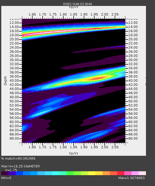
YUM Yuma, CO - Earthquake Result Viewer
| Earthquake location: |
Colombia |
| Earthquake latitude/longitude: |
5.1/-75.7 |
| Earthquake time(UTC): |
1992/08/15 (228) 19:02:09 GMT |
| Earthquake Depth: |
127 km |
| Earthquake Magnitude: |
5.7 MB |
| Earthquake Catalog/Contributor: |
WHDF/NEIC |
|
| Network: |
XG Rocky Mountain Front |
| Station: |
YUM Yuma, CO |
| Lat/Lon: |
40.16 N/102.78 W |
| Elevation: |
1284 m |
|
| Distance: |
42.6 deg |
| Az: |
328.995 deg |
| Baz: |
137.967 deg |
| Ray Param: |
0.07263655 |
| Estimated Moho Depth: |
16.25 km |
| Estimated Crust Vp/Vs: |
1.75 |
| Assumed Crust Vp: |
6.483 km/s |
| Estimated Crust Vs: |
3.704 km/s |
| Estimated Crust Poisson's Ratio: |
0.26 |
|
| Radial Match: |
90.091995 % |
| Radial Bump: |
400 |
| Transverse Match: |
67.67007 % |
| Transverse Bump: |
400 |
| SOD ConfigId: |
3286 |
| Insert Time: |
2010-02-25 20:12:27.856 +0000 |
| GWidth: |
2.5 |
| Max Bumps: |
400 |
| Tol: |
0.001 |
|

Signal To Noise
| Channel | StoN | STA | LTA |
| XG:YUM:02:BHN:19920815T19:09:22.740002Z | 0.8006825 | 2.3996207E-4 | 2.996969E-4 |
| XG:YUM:02:BHE:19920815T19:09:22.740002Z | 1.2663165 | 3.0613082E-4 | 2.4174903E-4 |
| XG:YUM:02:BHZ:19920815T19:09:22.740002Z | 7.190469 | 0.001501951 | 2.0888081E-4 |
| Arrivals |
| Ps | 2.0 SECOND |
| PpPs | 6.4 SECOND |
| PsPs/PpSs | 8.4 SECOND |


