You are here: Home > Network List > XG92 - Rocky Mountain Front Stations List
> Station YUM Yuma, CO > Earthquake Result Viewer
YUM Yuma, CO - Earthquake Result Viewer

| Earthquake location: |
Svalbard Region |
| Earthquake latitude/longitude: |
78.5/5.1 |
| Earthquake time(UTC): |
1992/07/20 (202) 07:46:46 GMT |
| Earthquake Depth: |
10 km |
| Earthquake Magnitude: |
5.8 MB, 6.3 MS |
| Earthquake Catalog/Contributor: |
WHDF/NEIC |
|
| Network: |
XG Rocky Mountain Front |
| Station: |
YUM Yuma, CO |
| Lat/Lon: |
40.16 N/102.78 W |
| Elevation: |
1284 m |
|
| Distance: |
54.4 deg |
| Az: |
296.213 deg |
| Baz: |
13.624 deg |
| Ray Param: |
0.06546931 |
| Estimated Moho Depth: |
48.0 km |
| Estimated Crust Vp/Vs: |
1.72 |
| Assumed Crust Vp: |
6.483 km/s |
| Estimated Crust Vs: |
3.763 km/s |
| Estimated Crust Poisson's Ratio: |
0.25 |
|
| Radial Match: |
95.79734 % |
| Radial Bump: |
221 |
| Transverse Match: |
82.058846 % |
| Transverse Bump: |
400 |
| SOD ConfigId: |
3286 |
| Insert Time: |
2010-02-25 20:12:30.062 +0000 |
| GWidth: |
2.5 |
| Max Bumps: |
400 |
| Tol: |
0.001 |
|
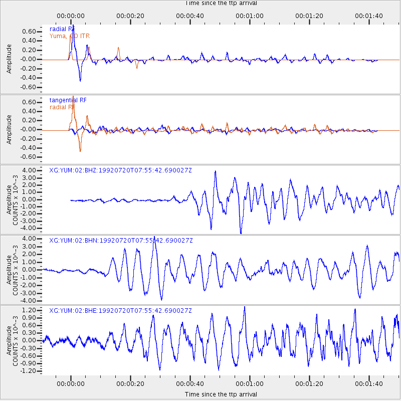
Signal To Noise
| Channel | StoN | STA | LTA |
| XG:YUM:02:BHN:19920720T07:55:42.690027Z | 1.2818419 | 1.660387E-4 | 1.2953134E-4 |
| XG:YUM:02:BHE:19920720T07:55:42.690027Z | 0.8479899 | 1.2526568E-4 | 1.4772071E-4 |
| XG:YUM:02:BHZ:19920720T07:55:42.690027Z | 1.5712564 | 1.871497E-4 | 1.191083E-4 |
| Arrivals |
| Ps | 5.7 SECOND |
| PpPs | 19 SECOND |
| PsPs/PpSs | 25 SECOND |


