You are here: Home > Network List > XG92 - Rocky Mountain Front Stations List
> Station YUM Yuma, CO > Earthquake Result Viewer
YUM Yuma, CO - Earthquake Result Viewer
| Earthquake location: |
Off East Coast Of Honshu, Japan |
| Earthquake latitude/longitude: |
39.4/143.4 |
| Earthquake time(UTC): |
1992/07/18 (200) 08:36:59 GMT |
| Earthquake Depth: |
33 km |
| Earthquake Magnitude: |
6.1 MB, 6.9 MS |
| Earthquake Catalog/Contributor: |
WHDF/NEIC |
|
| Network: |
XG Rocky Mountain Front |
| Station: |
YUM Yuma, CO |
| Lat/Lon: |
40.16 N/102.78 W |
| Elevation: |
1284 m |
|
| Distance: |
80.5 deg |
| Az: |
45.296 deg |
| Baz: |
314.027 deg |
| Ray Param: |
0.048212618 |
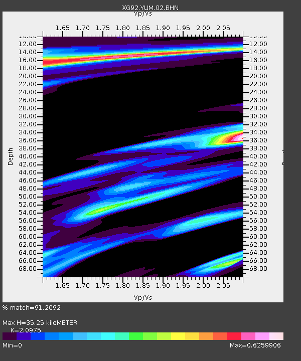
| Estimated Moho Depth: |
35.25 km |
| Estimated Crust Vp/Vs: |
2.10 |
| Assumed Crust Vp: |
6.483 km/s |
| Estimated Crust Vs: |
3.091 km/s |
| Estimated Crust Poisson's Ratio: |
0.35 |
|
| Radial Match: |
91.2092 % |
| Radial Bump: |
344 |
| Transverse Match: |
69.81274 % |
| Transverse Bump: |
400 |
| SOD ConfigId: |
3286 |
| Insert Time: |
2010-02-25 20:12:31.384 +0000 |
| GWidth: |
2.5 |
| Max Bumps: |
400 |
| Tol: |
0.001 |
|
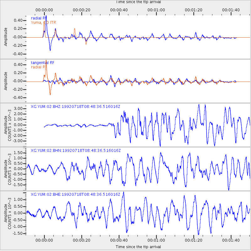
Signal To Noise
| Channel | StoN | STA | LTA |
| XG:YUM:02:BHN:19920718T08:48:36.516016Z | 0.65664446 | 2.1111708E-4 | 3.2150897E-4 |
| XG:YUM:02:BHE:19920718T08:48:36.516016Z | 1.0146917 | 2.111161E-4 | 2.0805935E-4 |
| XG:YUM:02:BHZ:19920718T08:48:36.516016Z | 1.0562397 | 1.3196586E-4 | 1.2493931E-4 |
| Arrivals |
| Ps | 6.1 SECOND |
| PpPs | 16 SECOND |
| PsPs/PpSs | 23 SECOND |


