You are here: Home > Network List > XG92 - Rocky Mountain Front Stations List
> Station YUM Yuma, CO > Earthquake Result Viewer
YUM Yuma, CO - Earthquake Result Viewer
| Earthquake location: |
Near East Coast Of Kamchatka |
| Earthquake latitude/longitude: |
51.2/157.7 |
| Earthquake time(UTC): |
1992/07/13 (195) 15:34:05 GMT |
| Earthquake Depth: |
53 km |
| Earthquake Magnitude: |
5.7 MB |
| Earthquake Catalog/Contributor: |
WHDF/NEIC |
|
| Network: |
XG Rocky Mountain Front |
| Station: |
YUM Yuma, CO |
| Lat/Lon: |
40.16 N/102.78 W |
| Elevation: |
1284 m |
|
| Distance: |
65.2 deg |
| Az: |
56.336 deg |
| Baz: |
316.851 deg |
| Ray Param: |
0.058294073 |
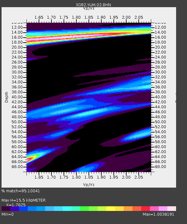
| Estimated Moho Depth: |
15.5 km |
| Estimated Crust Vp/Vs: |
1.78 |
| Assumed Crust Vp: |
6.483 km/s |
| Estimated Crust Vs: |
3.637 km/s |
| Estimated Crust Poisson's Ratio: |
0.27 |
|
| Radial Match: |
95.10041 % |
| Radial Bump: |
400 |
| Transverse Match: |
87.96982 % |
| Transverse Bump: |
400 |
| SOD ConfigId: |
3286 |
| Insert Time: |
2010-02-25 20:12:34.424 +0000 |
| GWidth: |
2.5 |
| Max Bumps: |
400 |
| Tol: |
0.001 |
|

Signal To Noise
| Channel | StoN | STA | LTA |
| XG:YUM:02:BHN:19920713T15:44:10.710022Z | 1.515471 | 1.7329874E-4 | 1.1435306E-4 |
| XG:YUM:02:BHE:19920713T15:44:10.710022Z | 1.0895731 | 1.634008E-4 | 1.4996772E-4 |
| XG:YUM:02:BHZ:19920713T15:44:10.710022Z | 3.6410763 | 3.6809212E-4 | 1.01094316E-4 |
| Arrivals |
| Ps | 2.0 SECOND |
| PpPs | 6.4 SECOND |
| PsPs/PpSs | 8.3 SECOND |


